Difference between revisions of "Carpenter Island"
Westarctica (talk | contribs) m |
Westarctica (talk | contribs) |
||
| (One intermediate revision by the same user not shown) | |||
| Line 1: | Line 1: | ||
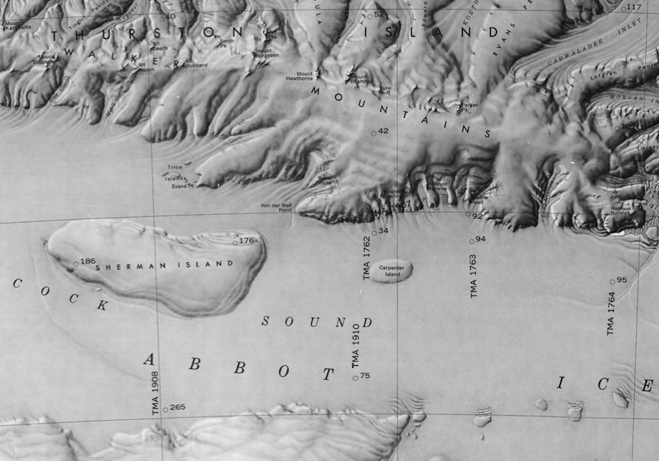
[[File:Peacock Sound-Islands.png|350px|thumb|Map showing Carpenter Island and Sherman Island in the Peacock Sound]] | [[File:Peacock Sound-Islands.png|350px|thumb|Map showing Carpenter Island and Sherman Island in the Peacock Sound]] | ||
Carpenter Island is a 7 mile long oval-shaped island located in the [[Peacock Sound]]. | Carpenter Island (72°41'S 97°57'W) is a 7 mile long oval-shaped island located in the [[Peacock Sound]]. | ||
==Location== | ==Location== | ||
| Line 9: | Line 9: | ||
Strangely, the area directly over Carpenter Island was left whited out on a graphic created by the USGS in 1975. The graphic in question was satellite imagery of the coast of [[Westarctica]] collected by NASA from 1972 - 1974. It is unknown why that portion of the graphic was not properly imaged. | Strangely, the area directly over Carpenter Island was left whited out on a graphic created by the USGS in 1975. The graphic in question was satellite imagery of the coast of [[Westarctica]] collected by NASA from 1972 - 1974. It is unknown why that portion of the graphic was not properly imaged. | ||
==Peerage title== | |||
On 7 May 2024, Mark E. Boehm was granted the [[Peerage of Westarctica|peerage title]] Duke of Carpenter Island in recognition of his support of [[Westarctica]]. His title is so-named for this island. | |||
[[Category: Islands]] | [[Category: Islands]] | ||
Latest revision as of 17:02, 8 May 2024
Carpenter Island (72°41'S 97°57'W) is a 7 mile long oval-shaped island located in the Peacock Sound.
Location
The island lies 17 miles due east of the much larger Sherman Island, and is entirely locked within the Abbot Ice Shelf. It is between Thurston Island and the Eights Coast.
Discovery and name
Carpenter Island was mapped by the U.S. Geologic Survey from surveys and U.S. Navy air photos that were collected during the years 1960-66. It was named by the Advisory Committee on Antarctic Names in honor of Donald L. Carpenter, who served as a radio scientist at Byrd Station during the 1966-67 research season.
Strangely, the area directly over Carpenter Island was left whited out on a graphic created by the USGS in 1975. The graphic in question was satellite imagery of the coast of Westarctica collected by NASA from 1972 - 1974. It is unknown why that portion of the graphic was not properly imaged.
Peerage title
On 7 May 2024, Mark E. Boehm was granted the peerage title Duke of Carpenter Island in recognition of his support of Westarctica. His title is so-named for this island.
