Difference between revisions of "Cronenwett Island"
(Created page with "'''Cronenwett Island''' (Coordinates: 77°0′S 150°0′W) is a high, ice-covered island about 40 kilometers (20 nmi) long. It lies between Vollmer Island and Steventon Islan...") |
Westarctica (talk | contribs) (added map of island) |
||
| Line 1: | Line 1: | ||
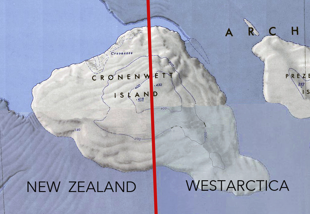
'''Cronenwett Island''' (Coordinates: 77°0′S 150°0′W) is a high, ice-covered island about 40 kilometers (20 nmi) long. It lies between Vollmer Island and Steventon Island in the [[Marshall Archipelago]], off the coast of Westarctica. The feature was first observed and roughly delineated from aerial photographs taken by the Byrd Antarctic Expedition, 1928–30. It was named by the Advisory Committee on Antarctic Names for Commander W.R. Cronenwett, U.S. Navy, Photographic Officer for Deep Freeze II, 1956–57, and Public Information Officer for Task Group 43.1 during Deep Freeze 1962. | [[File:Cronenwett-Island.jpg|400px|thumb|Composite map showing the 150 degree line dividing Cronenwett Island between New Zealand (Ross Dependency) and Westarctica]] | ||
'''Cronenwett Island''' (Coordinates: 77°0′S 150°0′W) is a high, ice-covered island about 40 kilometers (20 nmi) long. It lies between Vollmer Island and Steventon Island in the [[Marshall Archipelago]], off the coast of [[Westarctica]]. The feature was first observed and roughly delineated from aerial photographs taken by the Byrd Antarctic Expedition, 1928–30. It was named by the Advisory Committee on Antarctic Names for Commander W.R. Cronenwett, [[U.S. Navy]], Photographic Officer for Deep Freeze II, 1956–57, and Public Information Officer for Task Group 43.1 during Deep Freeze 1962. | |||
The island is located in [[Sulzberger Bay]], and is divided by the 150° longitude line, meaning that half of the island is claimed by New Zealand as part of the [[Ross Dependency]] and the other half by Westarctica. | The island is located in [[Sulzberger Bay]], and is divided by the 150° longitude line, meaning that half of the island is claimed by New Zealand as part of the [[Ross Dependency]] and the other half by Westarctica. | ||
[[Category:Islands]] | |||
[[Category:Geography of Westarctica]] | |||
Revision as of 03:12, 11 May 2018
Cronenwett Island (Coordinates: 77°0′S 150°0′W) is a high, ice-covered island about 40 kilometers (20 nmi) long. It lies between Vollmer Island and Steventon Island in the Marshall Archipelago, off the coast of Westarctica. The feature was first observed and roughly delineated from aerial photographs taken by the Byrd Antarctic Expedition, 1928–30. It was named by the Advisory Committee on Antarctic Names for Commander W.R. Cronenwett, U.S. Navy, Photographic Officer for Deep Freeze II, 1956–57, and Public Information Officer for Task Group 43.1 during Deep Freeze 1962.
The island is located in Sulzberger Bay, and is divided by the 150° longitude line, meaning that half of the island is claimed by New Zealand as part of the Ross Dependency and the other half by Westarctica.
