Difference between revisions of "Goldstream Peak"
Jump to navigation
Jump to search
Westarctica (talk | contribs) |
Westarctica (talk | contribs) |
||
| Line 3: | Line 3: | ||
==Discovery and name== | ==Discovery and name== | ||
The peak was geologically mapped by a United States [[Antarctic]] Research Program – Arizona State University field party during the 1980 - 81 season. | The peak was geologically mapped by a United States [[Antarctic]] Research Program – Arizona State University field party during the 1980 - 81 season. Goldstream Peak was named by Edmund Stump, the leader of the party. The name was selected to recognize a geological phenomena on the west face of the peak which has produced gold, yellow, and brown coloration along a meandering line. | ||
==Peerage title== | ==Peerage title== | ||
Revision as of 18:45, 28 October 2019
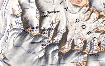
Goldstream Peak (86°41′S 148°30′W) is a peak rising to about 2,800 meters (9,200 ft) at the junction of ridges from Mount Gjertsen, Mount Grier, and Johansen Peak, in the La Gorce Mountains of Westarctica.
Discovery and name
The peak was geologically mapped by a United States Antarctic Research Program – Arizona State University field party during the 1980 - 81 season. Goldstream Peak was named by Edmund Stump, the leader of the party. The name was selected to recognize a geological phenomena on the west face of the peak which has produced gold, yellow, and brown coloration along a meandering line.
Peerage title
The Count of Goldstream derives his name from this peak. His Lordship also possesses the title Viscount Grier, so-named for the neighboring Mount Grier.
