Search results
Jump to navigation
Jump to search
Page title matches
- [[File:Carney Island Map.png|350px|thumb|Map of Carney Island]] ...st of [[Westarctica]]. It is located between [[Siple Island]] and [[Wright Island]] along the coast of [[Marie Byrd Land]].2 KB (262 words) - 09:54, 22 April 2020
- [[File:Benton-Island-Map.jpg|thumb|500px|Map showing Benton Island in the Marshall Archipelago]] ...lying 9 kilometers (5 nmi) northwest of [[Nolan Island]] near [[Steventon Island]] in the [[Marshall Archipelago]].965 bytes (138 words) - 10:00, 2 January 2021
- '''Newman Island''' is an [[ice]]-covered island 28 kilometers (15 nmi) long, lying in the [[Nickerson Ice Shelf]] on the co ...y the United States Geological Survey and [[U.S. Navy]] air photos. Newman Island was named by the Advisory Committee on [[Antarctic]] Names in honor of Cdr.517 bytes (81 words) - 15:35, 16 September 2019
- [[File:Tucker Point.png|thumb|350px|Map of the Murray Foreland showing Carter Island]] '''Carter Island''' is a small, [[ice]]-covered island in Glade Bay, off the west side of the [[Martin Peninsula]], on the [[Bakut924 bytes (138 words) - 23:14, 8 September 2021
- ...Moore.jpg|350px|thumb|Map showing the location of Moore Barony and Farmer Island]] ...vered island about 13 kilometers long, lying 9 kilometers west of [[Farmer Island]] in the [[Marshall Archipelago]].1 KB (160 words) - 10:36, 7 April 2020
- [[File:Alexander-Island.jpg|thumb|400px|Fossil Bluff Base on Alexander Island]] ...la]] from which it is separated by Marguerite Bay and George VI Sound. The island is about 390 kilometers (240 mi) long in a north-south direction, 80 kilome3 KB (483 words) - 19:29, 1 May 2018
- [[File:Getz Ice Shelf to Bear Island.jpg|thumb|upright=2.0]] ...hin the [[Getz Ice Shelf]] and midway between [[Grant Island]] and [[Siple Island]], off the coast of [[Westarctica]].977 bytes (149 words) - 18:23, 24 January 2023
- [[File:Barony of Moore.jpg|thumb|350px|Map showing the location of Farmer Island]] ...6 miles north of [[Radford Island]] and 5 nautical miles east of [[Morris Island]] in the [[Marshall Archipelago]] along the coast of [[Westarctica]].1 KB (158 words) - 21:56, 23 November 2021
- [[File:Loc-wright.jpg|thumb|200px|Location of Wright Island]] ...ing at the north edge of [[Scott Peninsula]] about midway between [[Carney Island]] and the [[Martin Peninsula]], on the [[Bakutis Coast]] of [[Westarctica]]1 KB (190 words) - 08:17, 17 January 2021
- [[File:Dendtler.jpg|thumb|Dendtler Island]] ...ng, lying in the eastern part of the [[Abbot Ice Shelf]] between [[Farwell Island]] in [[Westarctica]] and the Fletcher Peninsula in Antarctica. [[Lepley Nun1 KB (153 words) - 16:49, 15 September 2021
- [[File:Farwell Island Map.png|thumb|Map of Farwell Island]] ...kilometers (10 nmi) wide, lying between [[McNamara Island]] and [[Dendtler Island]] in the eastern part of the [[Abbot Ice Shelf]] on [[Westarctica]]'s easte1 KB (157 words) - 08:37, 11 March 2022
- [[File:Radford-Island-Map.png|350px|thumb|Map of Radford Island in the Marshall Archipelago]] '''Radford Island''' (76°54′S 146°36′W) is an [[ice]]-covered island surmounted by several peaks, lying 6 nautical miles (11 km) west of [[Saund1 KB (188 words) - 05:29, 25 June 2020
- ...ap showing the location of Lauff and Burtis Islands off the coast of Siple Island.]] ...small island lying 4 kilometers (2 nmi) north of [[Cape Dart]] and [[Siple Island]] along the [[Bakutis Coast]] of [[Westarctica]].1 KB (154 words) - 05:15, 11 March 2022
- ...byszewski Island. Note that the USGS chart has misspelled the name of the island]] ...t lies 5.6 kilometers (3 nmi) east of [[Cronenwett Island]], near [[Benton Island]] in the western part of [[Sulzberger Ice Shelf]].1 KB (178 words) - 18:30, 2 December 2019
- [[File:Marshall-Islands.png|thumb|350px|Map showing location of Orr Island in relation to other islands in the Marshall Archipelago]] ...lometers (5 nmi) long, lying 5.6 kilometers (3 nmi) southwest of [[Grinder Island]] in the [[Marshall Archipelago]], off the coast of [[Westarctica]].997 bytes (148 words) - 01:57, 25 July 2020
- [[File:Sabrina Island1.png|thumb|Sabrina Island from the air]] ...the largest of three small islets lying 1.5 km (0.93 mi) south of [[Buckle Island]] in the [[Balleny Islands]] off the coast of continental [[Antarctica]].2 KB (237 words) - 06:59, 23 December 2019
- ...e:Hannah-Hutchinson.jpg|350px|thumb|Map showing the location of Hutchinson Island]] ...ng 19 kilometers (10 nmi) east of Vollmer Island and due south of [[Hannah Island]] in the [[Marshall Archipelago]]. Its location is only a few meters from t1 KB (201 words) - 17:33, 25 January 2024
- [[File:Hannah-Hutchinson.jpg|350px|thumb|Map showing the location of Hannah Island]] ...er Ice Shelf]], off the coast of [[Westarctica]]. The highest point on the island is a 159 meter unnamed peak.1 KB (192 words) - 16:12, 2 March 2024
- [[File:Steventon-Island-Map.png|350px|thumb|Map showing Steventon Island and surrounding islands in the Marshall Archipelago]] '''Steventon Island''' (77°15′S 148°15′W) is a broad [[ice]]-covered island about 39 km (24 mi) off of the coast of [[Westarctica]] in the [[Marshall A1 KB (155 words) - 21:05, 28 August 2023
- [[File:Cherry-Island.jpg|350px|thumb|Map showing the location of Cherry Island]] ...e]]-covered island, 3 mi long, lying between [[Siple Island]] and [[Carney Island]] within the [[Getz Ice Shelf]], along the northern coast of [[Westarctica]961 bytes (143 words) - 06:46, 22 April 2019
Page text matches
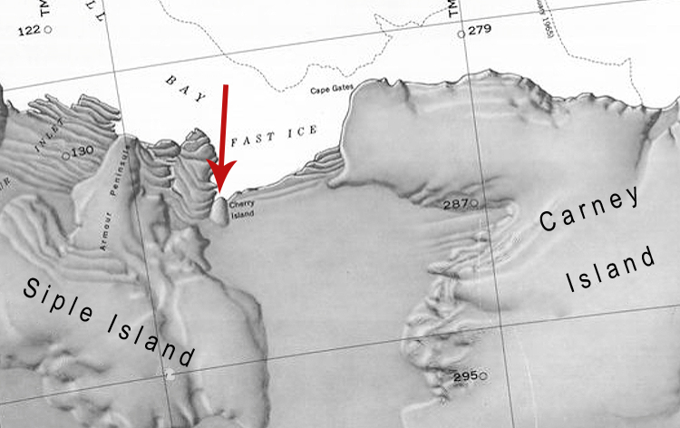
File:Cherry-Island.jpg Map showing the location of Cherry Island between Siple Island and Carney Island off the coast of Antarctica.(750 × 472 (181 KB)) - 06:46, 22 April 2019- ...d island 19 kilometers (10 nmi) long, between Kizer Island and [[Steventon Island]] in the [[Sulzberger Ice Shelf]]. ...nd from [[U.S. Navy]] air photos collected during the years 1959–65. Moody Island was named by the Advisory Committee on [[Antarctic]] Names for E.L. Moody,500 bytes (72 words) - 17:44, 4 September 2021
File:McNamaraMap.jpg Map showing McNamara Island in relation to Thurston Island.(805 × 635 (26 KB)) - 23:23, 5 April 2018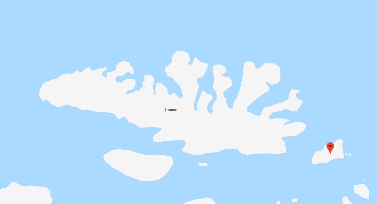
File:DustinMap.jpg Map showing Dustin Island in relation to Thurston Island.(1,269 × 688 (34 KB)) - 23:28, 5 April 2018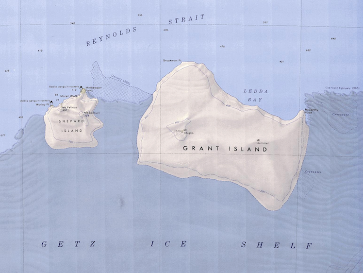
File:Grand-Shepard-Map.png Map showing Grand Island and Shepard Island together.(748 × 562 (662 KB)) - 06:47, 18 April 2018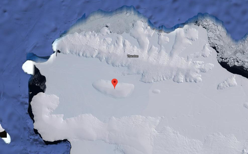
File:Sherman Island Satellite Image.png ...llite image showing the location of Sherman Island in relation to Thurston Island.(986 × 615 (582 KB)) - 04:25, 30 March 2018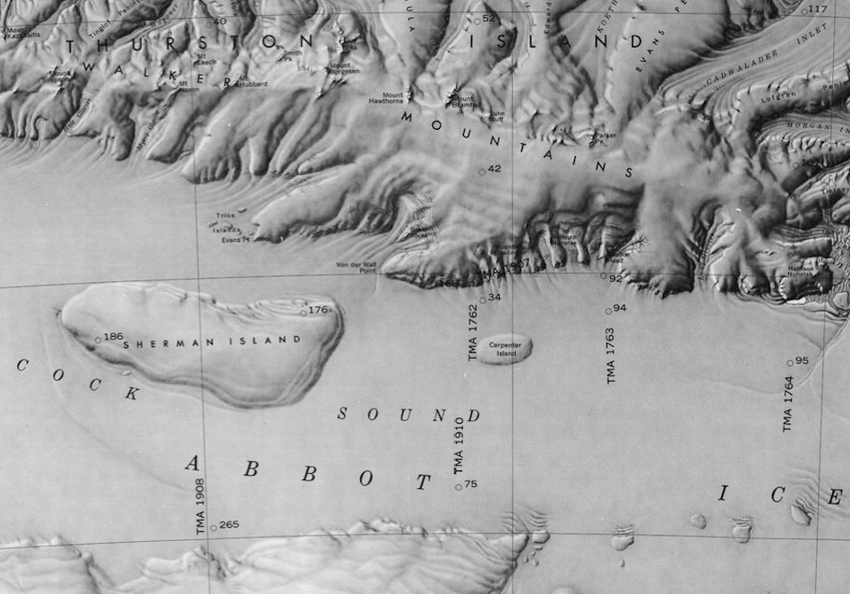
File:Peacock Sound-Islands.png Map showing Carpenter Island and Sherman Island in the Peacock Sound.(949 × 663 (781 KB)) - 16:46, 23 February 2019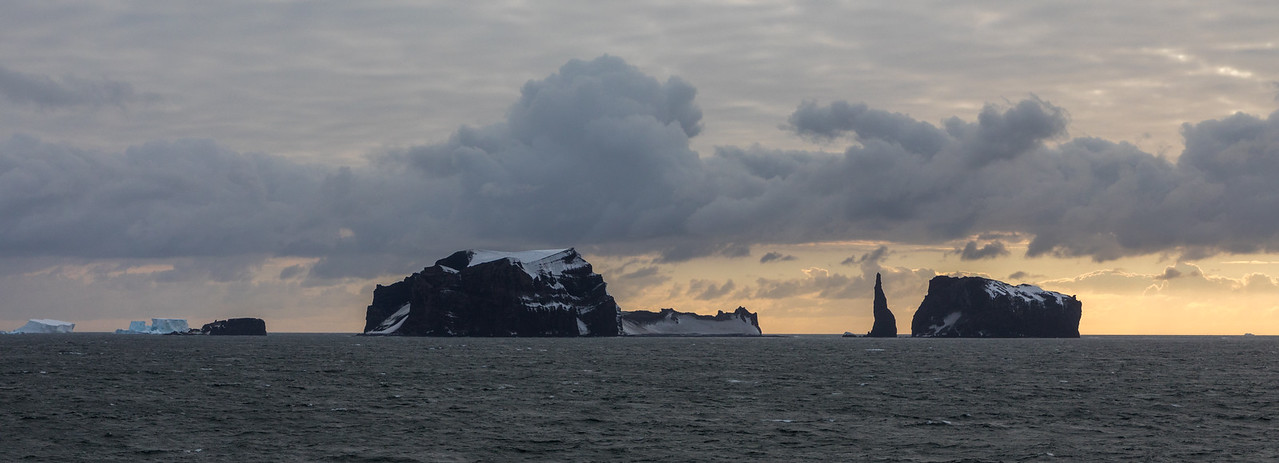
File:Chinstrap Island.jpg Panorama showing (L to R) Chinstrap Island, Sabrina Island, and The Monolith(1,279 × 463 (118 KB)) - 19:34, 1 October 2018- ...d Island Map.png|thumb|Map of Shepard Island showing Western edge of Grant Island]] ...6 miles west of [[Grant Island]] off the coast of [[Westarctica]]. Shepard Island is [[ice]]-capped except at its northern, seaward side, and is almost wholl782 bytes (113 words) - 09:04, 28 August 2020
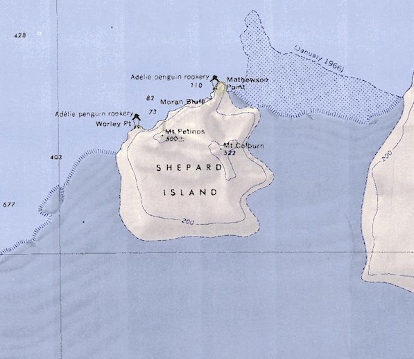
File:Shepard Island Map.png Map of Shepard Island showing Western edge of Grant Island.(597 × 519 (515 KB)) - 06:48, 18 April 2018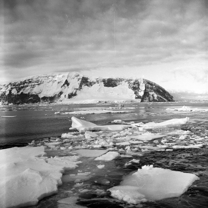
File:SturgeIsland-Balleny.jpg Description: Balleny Islands: Sturge Island Location: Sturge Island(724 × 724 (143 KB)) - 19:59, 1 October 2018- [[File:Grand-Shepard-Map.png|thumb|Map showing Grand Island and Shepard Island together]] ...Island]] off the coast of [[Marie Byrd Land]]. Like Shepard Island, Grant Island is surrounded by the [[Getz Ice Shelf]] on all but the north side.782 bytes (119 words) - 21:59, 2 May 2018
- ...byszewski Island. Note that the USGS chart has misspelled the name of the island]] ...t lies 5.6 kilometers (3 nmi) east of [[Cronenwett Island]], near [[Benton Island]] in the western part of [[Sulzberger Ice Shelf]].1 KB (178 words) - 18:30, 2 December 2019
- ...73°14′S 124°55′W) is a small [[ice]]-covered island lying close to [[Siple Island]] in the west extremity of Russell Bay, off the coast of [[Westarctica]]. ...l Survey from ground surveys and [[U.S. Navy]] air photos, 1959-65. Pranke Island was named for James B. Pranke, an aurora researcher at [[Byrd Station]] in927 bytes (138 words) - 04:52, 10 May 2018
- ...a cove at the north side of [[Cape Ingrid]] on the west side of [[Peter I Island]]. ...hich visited the island in February 1929. The crew engaged in charting the island and in sounding and dredging operations.349 bytes (56 words) - 04:00, 28 February 2019
- ...separating Westarctica from the [[Ross Dependency]]. Sovereignty over the island is split between Westarctica and New Zealand at this line. ...hall Archipelago belong to Westarctica except for Vollmer Island and Kizer Island. This includes the following islands:2 KB (231 words) - 10:18, 2 January 2021
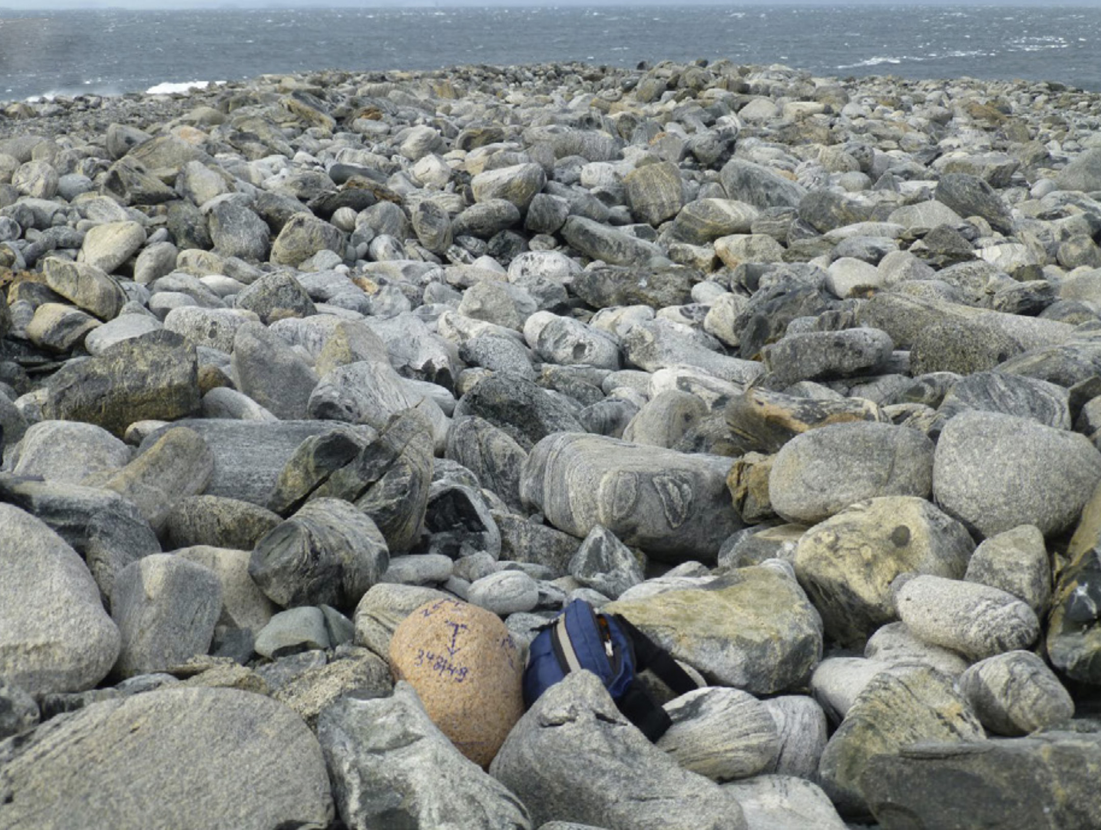
File:Dryment Island.jpg Description: Rock formations on Dryment Island. Location: Dryment Island, Antarctica(2,160 × 1,630 (870 KB)) - 22:32, 26 June 2020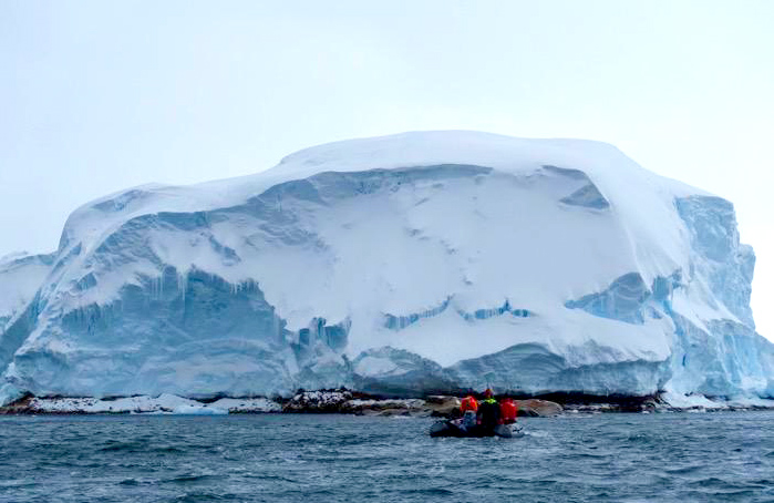
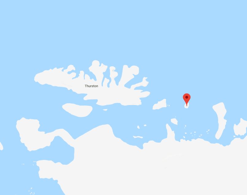
File:Sif Island.jpg Description: Photograph of Sif Island off the coast of Antarctica. Location: Pine Island Bay, Westarctica(699 × 454 (147 KB)) - 16:44, 20 August 2023- ...araMap.jpg|thumb|400px|Map showing McNamara Island in relation to Thurston Island]] ...near [[Thurston Island]] about 20 nautical miles (37 km) east of [[Dustin Island]] on the extreme eastern border of [[Westarctica]].766 bytes (109 words) - 08:37, 11 March 2022
- ...ustinMap.jpg|thumb|450px|Map showing Dustin Island in relation to Thurston Island]] ...utheast of [[Thurston Island]] on the eastern edge of [[Westarctica]]. The island forms the SE limit of [[Seraph Bay]].737 bytes (109 words) - 23:29, 5 April 2018


