Difference between revisions of "Template:POTD protected"
Westarctica (talk | contribs) |
Westarctica (talk | contribs) |
||
| Line 1: | Line 1: | ||
{| role="presentation" style="margin:0 3px 3px; width:100%; text-align:left; background-color:transparent; border-collapse: collapse; " | {| role="presentation" style="margin:0 3px 3px; width:100%; text-align:left; background-color:transparent; border-collapse: collapse; " | ||
|style="padding:0 0.9em 0 0;" | [[File: | |style="padding:0 0.9em 0 0;" | [[File:Koloc-Point.png|300px]] | ||
|style="padding:0 6px 0 0"| | |style="padding:0 6px 0 0"| | ||
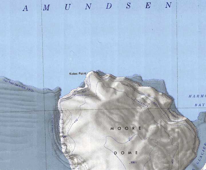
'''[[Moore Dome]]''' (74°20′S 111°20′W) is an ice dome, circular in plan and 15 nautical miles (28 km) in extent, rising to 700 meters (2,300 ft) and forming the northwest portion of the [[Bear Peninsula]], along [[Westarctica]]'s [[Walgreen Coast]]. [[Koloc Point]] is at the northern extremity of the coast of the dome. | |||
Moore Dome was mapped by the United States Geological Survey from aerial photographs taken by [[U.S. Navy]] Operation Highjump in 1947 and the U.S. Navy in 1966. It was named by the Advisory Committee on [[Antarctic]] Names in 1977 after Captain Robert G. Moore, USCG, Commanding Officer of USCGC ''Burton Island''. The ''Burton Island'' conducted operations in the [[Ross Sea]], [[Pine Island Bay]], and along the [[Antarctic Peninsula]] during the 1974–75 season. | |||
<p><small>Map Credit: U.S. Geological Survey </small></p> | |||
<p><small> | |||
[[:Category:Images|'''(More Featured Images)''']] | [[:Category:Images|'''(More Featured Images)''']] | ||
<div class="potd-recent" style="text-align:right;"> | <div class="potd-recent" style="text-align:right;"> | ||
Revision as of 17:54, 10 June 2019

|
Moore Dome (74°20′S 111°20′W) is an ice dome, circular in plan and 15 nautical miles (28 km) in extent, rising to 700 meters (2,300 ft) and forming the northwest portion of the Bear Peninsula, along Westarctica's Walgreen Coast. Koloc Point is at the northern extremity of the coast of the dome. Moore Dome was mapped by the United States Geological Survey from aerial photographs taken by U.S. Navy Operation Highjump in 1947 and the U.S. Navy in 1966. It was named by the Advisory Committee on Antarctic Names in 1977 after Captain Robert G. Moore, USCG, Commanding Officer of USCGC Burton Island. The Burton Island conducted operations in the Ross Sea, Pine Island Bay, and along the Antarctic Peninsula during the 1974–75 season. Map Credit: U.S. Geological Survey |