Difference between revisions of "Template:POTD protected"
Jump to navigation
Jump to search
Westarctica (talk | contribs) |
Westarctica (talk | contribs) |
||
| Line 1: | Line 1: | ||
{| role="presentation" style="margin:0 3px 3px; width:100%; text-align:left; background-color:transparent; border-collapse: collapse; " | {| role="presentation" style="margin:0 3px 3px; width:100%; text-align:left; background-color:transparent; border-collapse: collapse; " | ||
|style="padding:0 0.9em 0 0;" | [[File: | |style="padding:0 0.9em 0 0;" | [[File:Dorrel Rock - Mt. Murphy.jpg|300px]] | ||
|style="padding:0 6px 0 0"| | |style="padding:0 6px 0 0"| | ||
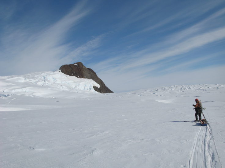
'''[[ | '''[[Dorrel Rock]]''' (75°26′S 111°22′W) is a rock outcrop 11 nautical miles (20 km) southwest of the summit of [[Mount Murphy]], protruding through the ice near the head of [[Pope Glacier]], on the [[Walgreen Coast]] in [[Westarctica]]. | ||
It was mapped by the United States Geological Survey from surveys and [[U.S. Navy]] air photos, 1959–66, and was named by the Advisory Committee on [[Antarctic]] Names after Leo E. Dorrel, U.S. Navy, a hospital corpsman with the [[Byrd Station]] winter party, 1966. On 2 November 2018, Westarctica's [[Honorary Consular Corps|Honorary Consul]] to Spain, Dr. Joachim Michael Adlfinger, was granted the [[Peerage of Westarctica|Peerage title]] of Baron of Dorrel in recognition of his successful opening of Westarctica's consulate office in southern Spain. | |||
<p><small> | <p><small>Photo Credit: British Antarctic Survey</small></p> | ||
[[:Category:Images|'''(More Featured Images)''']] | [[:Category:Images|'''(More Featured Images)''']] | ||
<div class="potd-recent" style="text-align:right;"> | <div class="potd-recent" style="text-align:right;"> | ||
Revision as of 19:38, 24 June 2019

|
Dorrel Rock (75°26′S 111°22′W) is a rock outcrop 11 nautical miles (20 km) southwest of the summit of Mount Murphy, protruding through the ice near the head of Pope Glacier, on the Walgreen Coast in Westarctica. It was mapped by the United States Geological Survey from surveys and U.S. Navy air photos, 1959–66, and was named by the Advisory Committee on Antarctic Names after Leo E. Dorrel, U.S. Navy, a hospital corpsman with the Byrd Station winter party, 1966. On 2 November 2018, Westarctica's Honorary Consul to Spain, Dr. Joachim Michael Adlfinger, was granted the Peerage title of Baron of Dorrel in recognition of his successful opening of Westarctica's consulate office in southern Spain. Photo Credit: British Antarctic Survey |