Difference between revisions of "Template:Westarctica.wiki:Today's featured article"
Westarctica (talk | contribs) |
Westarctica (talk | contribs) |
||
| Line 1: | Line 1: | ||
[[File: | [[File:Icesheet-Map.jpg|300px|left]] | ||
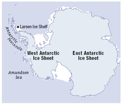
The '''[[ | The '''[[West Antarctic Ice Sheet]]''' (WAIS) is the segment of the continental [[ice sheet]] that covers [[Westarctica]] and the portion of [[Antarctica]] on the side of the [[Transantarctic Mountains]] which lies in the Western Hemisphere. The WAIS is classified as a marine-based ice sheet, meaning that its bed lies well below sea level and its edges flow into floating [[ice-shelf|ice shelves]]. The WAIS is bounded by the [[Ross Ice Shelf]], the [[Ronne Ice Shelf]], and outlet [[glacier]]s that drain into the [[Amundsen Sea]]. | ||
It is estimated that the volume of the [[Antarctic ice sheet]] is about 25.4 million km3 (6.1 million cu mi), and the WAIS contains just under 10% of this, or 2.2 million km3 (530,000 cu mi). The weight of the ice has caused the underlying rock to sink by between 0.5 and 1 kilometer (0.31 and 0.62 miles) in a process known as isostatic depression. | |||
When [[ice]] reaches the coast, it either calves or continues to flow outward onto the water. The result is a large, floating ice shelf affixed to the continent. | |||
'''([[ | '''([[West Antarctic Ice Sheet|Full Article...]])''' | ||
Revision as of 19:26, 21 April 2019
The West Antarctic Ice Sheet (WAIS) is the segment of the continental ice sheet that covers Westarctica and the portion of Antarctica on the side of the Transantarctic Mountains which lies in the Western Hemisphere. The WAIS is classified as a marine-based ice sheet, meaning that its bed lies well below sea level and its edges flow into floating ice shelves. The WAIS is bounded by the Ross Ice Shelf, the Ronne Ice Shelf, and outlet glaciers that drain into the Amundsen Sea.
It is estimated that the volume of the Antarctic ice sheet is about 25.4 million km3 (6.1 million cu mi), and the WAIS contains just under 10% of this, or 2.2 million km3 (530,000 cu mi). The weight of the ice has caused the underlying rock to sink by between 0.5 and 1 kilometer (0.31 and 0.62 miles) in a process known as isostatic depression.
When ice reaches the coast, it either calves or continues to flow outward onto the water. The result is a large, floating ice shelf affixed to the continent.
