Difference between revisions of "Template:Westarctica.wiki:Today's featured article"
Westarctica (talk | contribs) |
Westarctica (talk | contribs) |
||
| Line 1: | Line 1: | ||
[[File: | [[File:Mount-Petras.png|300px|left]] | ||
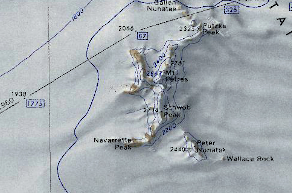
'''[[Mount Petras]]''' is a 2865 meter high prominent mountain in the shape of a ridge in [[Westarctica]]. The mountain is located 16 kilometers southeast of Mount Flint in the [[McCuddin Mountains]]. | |||
The ancient volcanic deposits at Mount Petras provide the oldest terrestrial evidence for [[glacier|glacial ice]] in Marie Byrd Land. The relatively high relief pre-volcanic environment is suggestive of ongoing erosion and is inconsistent with previous interpretations of a regional, low relief, early Cenozoic West Antarctic Erosion Surface. | |||
Scientists from the United States [[Antarctic]] Service Expedition (1939-1941) discovered Mount Petras during a flyover between 14 and 15 December 1940. The mountain was named in honor of Theodore Argyrios Petras (1911 - 2004), a master technical sergeant in the US Marine Corps, who served as the pilot of this flight. | |||
'''([[ | On 5 May 2015, the [[Peerage of Westarctica|peerage title]] Baroness of Petras was granted to Leila Rozumski as a gift from her mother, Jennifer. | ||
'''([[Mount Petras|Full Article...]])''' | |||
Revision as of 19:00, 1 July 2019
Mount Petras is a 2865 meter high prominent mountain in the shape of a ridge in Westarctica. The mountain is located 16 kilometers southeast of Mount Flint in the McCuddin Mountains.
The ancient volcanic deposits at Mount Petras provide the oldest terrestrial evidence for glacial ice in Marie Byrd Land. The relatively high relief pre-volcanic environment is suggestive of ongoing erosion and is inconsistent with previous interpretations of a regional, low relief, early Cenozoic West Antarctic Erosion Surface.
Scientists from the United States Antarctic Service Expedition (1939-1941) discovered Mount Petras during a flyover between 14 and 15 December 1940. The mountain was named in honor of Theodore Argyrios Petras (1911 - 2004), a master technical sergeant in the US Marine Corps, who served as the pilot of this flight.
On 5 May 2015, the peerage title Baroness of Petras was granted to Leila Rozumski as a gift from her mother, Jennifer.
