Difference between revisions of "Young Island"
Westarctica (talk | contribs) |
Westarctica (talk | contribs) |
||
| (6 intermediate revisions by the same user not shown) | |||
| Line 1: | Line 1: | ||
Young Island (66°17′S 162°25′E) is the northernmost and westernmost of the three main islands in the uninhabited [[Balleny Islands]] group located in the Southern Ocean. It lies 8 kilometers (5.0 mi) northwest of Buckle Island, some 115 kilometers (71 mi) north-northeast of Belousov Point on the Antarctic mainland. | [[File:Young Island-Balleny Islands.jpg|thumb|350px|right|Tip of Young Island]] | ||
'''Young Island''' (66°17′S 162°25′E) is the northernmost and westernmost of the three main islands in the uninhabited [[Balleny Islands]] group located in the [[Southern Ocean]]. It lies 8 kilometers (5.0 mi) northwest of [[Buckle Island]], some 115 kilometers (71 mi) north-northeast of Belousov Point on the [[Antarctica|Antarctic]] mainland. | |||
==Geography== | ==Geography== | ||
The island is roughly semi-oval in shape, with a long straight east coast and a curved west coast meeting at Cape Scoresby in the south and Cape Ellsworth in the north. The distance between these two capes is 19 nautical miles (22 mi), and at its widest the island is 4 nautical miles (4.6 mi) across. The island is volcanic, with active fumaroles (opening in or near a volcano, through which hot sulfurous gases emerge), and a height of 1,340 meters (4,400 feet). | The island is roughly semi-oval in shape, with a long straight east coast and a curved west coast meeting at Cape Scoresby in the south and Cape Ellsworth in the north. The distance between these two capes is 19 nautical miles (22 mi), and at its widest the island is 4 nautical miles (4.6 mi) across. The island is volcanic, with active fumaroles (opening in or near a volcano, through which hot sulfurous gases emerge), and a height of 1,340 meters (4,400 feet). | ||
| Line 10: | Line 10: | ||
==Annexation by Westarctica== | ==Annexation by Westarctica== | ||
Young Island was annexed by [[Westarctica]] on | Young Island was annexed by [[Westarctica]] on 14 January 2005 when it annexed the entire [[Balleny Islands]] group. | ||
As a member of the Balleny Islands, Young Island is governed by the [[Duke of Sherman]], who has served as Governor of the Balleny Islands since they were originally annexed from New Zealand. | |||
The island has been featured on two of Westarctica's [[Coins of Westarctica|coins]]: the first was a bronze $1 WAD coin minted in 2005 by the [[Central Bank of Westarctica]] and shows Young Island on a map of the Balleny Islands. The second coin was a brass $2 WAD coin minted in 2013 and was the last coin created by the Central Bank. That coin has an image of an [[Antarctic krill]] instead of the island itself. | |||
<gallery> | |||
Coin-Balleny Island 1 2005 Bronze.jpg|Balleny Islands Coin | |||
Young Island 2 dollars 2013.jpg|Young Island Coin | |||
</gallery> | |||
| Line 18: | Line 26: | ||
[[Category:Balleny Islands]] | [[Category:Balleny Islands]] | ||
[[Category:Geography of Westarctica]] | [[Category:Geography of Westarctica]] | ||
[[Category:Featured Articles]] | |||
Latest revision as of 20:12, 8 June 2023

Young Island (66°17′S 162°25′E) is the northernmost and westernmost of the three main islands in the uninhabited Balleny Islands group located in the Southern Ocean. It lies 8 kilometers (5.0 mi) northwest of Buckle Island, some 115 kilometers (71 mi) north-northeast of Belousov Point on the Antarctic mainland.
Geography
The island is roughly semi-oval in shape, with a long straight east coast and a curved west coast meeting at Cape Scoresby in the south and Cape Ellsworth in the north. The distance between these two capes is 19 nautical miles (22 mi), and at its widest the island is 4 nautical miles (4.6 mi) across. The island is volcanic, with active fumaroles (opening in or near a volcano, through which hot sulfurous gases emerge), and a height of 1,340 meters (4,400 feet).
It is entirely covered with snow. An explosive VEI-7 eruption occurred from Young Island 1,700,000 years ago.
Several small islets lie in the channel separating Cape Scoresby and Buckle Island, the largest of which is Borradaile Island. Several sea stacks lie off the island's northern tip. These are known as the Seal Rocks.
Annexation by Westarctica
Young Island was annexed by Westarctica on 14 January 2005 when it annexed the entire Balleny Islands group.
As a member of the Balleny Islands, Young Island is governed by the Duke of Sherman, who has served as Governor of the Balleny Islands since they were originally annexed from New Zealand.
The island has been featured on two of Westarctica's coins: the first was a bronze $1 WAD coin minted in 2005 by the Central Bank of Westarctica and shows Young Island on a map of the Balleny Islands. The second coin was a brass $2 WAD coin minted in 2013 and was the last coin created by the Central Bank. That coin has an image of an Antarctic krill instead of the island itself.
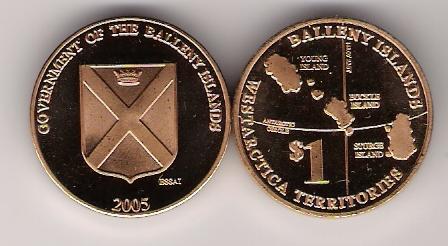
Balleny Islands Coin
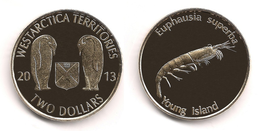
Young Island Coin

