File:Wallace Creek offset USGS.jpg
Wallace_Creek_offset_USGS.jpg (800 × 600 pixels, file size: 160 KB, MIME type: image/jpeg)
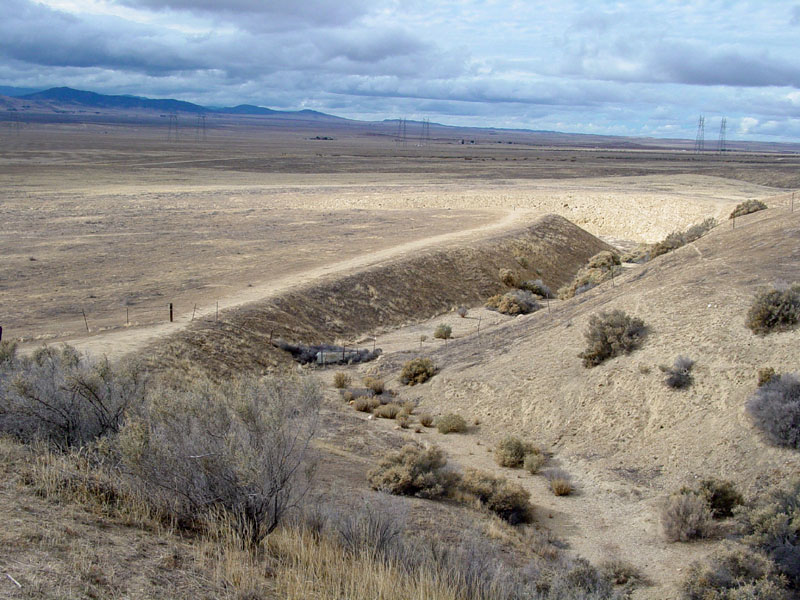
Description English: This view of the Wallace Creek (offset stream) is of perhaps the most famous feature on the San Andreas Fault. As the stream continues to progressively erode into its channel, right-lateral motion along the San Andreas Fault has moved the downstream portion of the channel northward. Sediments cut by Wallace Creek were radiocarbon dated at about 3,700 years old, and the stream channel has been offset about 430 feet since then (Sieh and Wallace, 1987). Earthquake fault investigations in the Carrizo Plain show that as many streams in the park area display evidence of right-lateral slip. Offset from the 1857 earthquake was in the range of 30 feet; two earlier earthquakes had slip displacements of about 40.6 feet (sometime between 1540 to 1630 A.D.) and 36 feet possibly between 1120 and 1300 A.D. (Sieh and Wallace, 1987). Offset along the fault shows a relative rate of motion in the in the Carrizo Plain (between A.D. 1210 and A.D. 1857) has averaged in the range of about 1.3 inches (34 mm) per year (Liu-Zeng and others, 2006). Date Unknown date Source https://3dparks.wr.usgs.gov/carrizo/html2/a101.htm Author USGS
File history
Click on a date/time to view the file as it appeared at that time.
| Date/Time | Thumbnail | Dimensions | User | Comment | |
|---|---|---|---|---|---|
| current | 18:46, 3 April 2018 | | 800 × 600 (160 KB) | Westarctica (talk | contribs) |
You cannot overwrite this file.
File usage
The following page uses this file: