Difference between revisions of "Billboard National Monument"
(Created page with "thumb|An aerial view of the Billboard '''Billboard National Monument''' (77°04′S 145°40′W) is a protected area of Westarctica...") |
(added link) |
||
| Line 9: | Line 9: | ||
The summit of the Billboard was first visited by Bruce Luyendyk and Kuno Lecha by helicopter in January 1993 during expedition GANOVEX VII. In 1998-99, Christine Siddoway led a geological party from Colorado College that reached the summit by climbing a west route. | The summit of the Billboard was first visited by Bruce Luyendyk and Kuno Lecha by helicopter in January 1993 during expedition GANOVEX VII. In 1998-99, Christine Siddoway led a geological party from Colorado College that reached the summit by climbing a west route. | ||
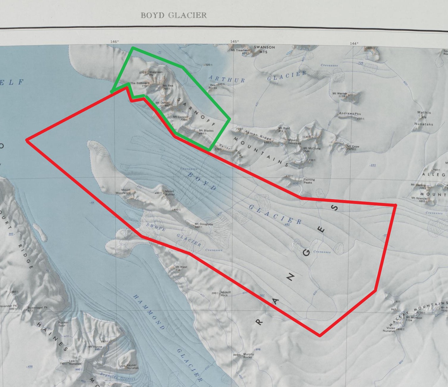
The Sarnoff Mountains were on the January 2024 list of ten sites that should be considered for eventual protection as a national park of Westarctica. Further research and consideration resulted in the current borders being on the list of five recommended areas to protect made by [[Duke of the Bear Peninsula|Jordan Farmer]] to [[Grand Duke Travis]] in March of 2025. On 20 April 2025, Grand Duke Travis declared the Billboard and surrounding portions of the western Sarnoff Mountains a national monument under the oversight of the [[Westarctican Parks Service]]. There are already legislative efforts to enshrine the Billboard as a national park, by combining it with Boyd Glacier Conservation Zone, which it borders. | The Sarnoff Mountains were on the January 2024 list of ten sites that should be considered for eventual protection as a national park of Westarctica. Further research and consideration resulted in the current borders being on the list of five recommended areas to protect made by [[Duke of the Bear Peninsula|Jordan Farmer]] to [[Grand Duke Travis]] in March of 2025. On 20 April 2025, Grand Duke Travis declared the Billboard and surrounding portions of the western Sarnoff Mountains a national monument under the oversight of the [[Westarctican Parks Service]]. There are already legislative efforts to enshrine the Billboard as a national park, by combining it with [[Boyd Glacier Conservation Zone]], which it borders. | ||
===Conservans Protectorem=== | ===Conservans Protectorem=== | ||
Latest revision as of 16:09, 28 April 2025
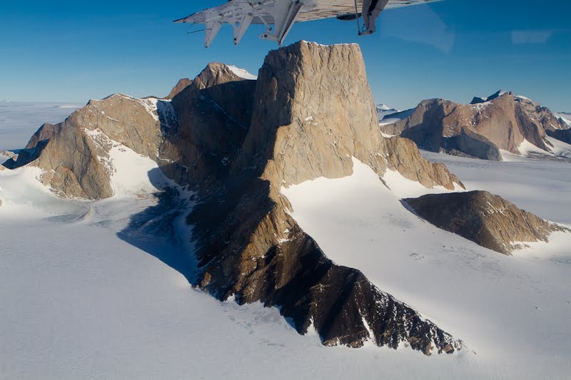
Billboard National Monument (77°04′S 145°40′W) is a protected area of Westarctica created to preserve the pristine landscape of the Billboard and the surrounding portion of the Sarnoff Mountains in the greater Ford Ranges. It was created via Royal Decree on 20 April 2005 by Grand Duke Travis. It falls under the oversight of the Westarctican Parks Service.
History
The west end of the Sarnoff range was discovered and roughly plotted from photos taken by Byrd Antarctic Expedition (1928–30) on the flight of 5 December 1929. The range was mapped in greater detail by the Byrd Antarctic Expedition (1933–35) and United States Antarctic Service (USAS) (1939–41), all expeditions led by Admiral Richard E. Byrd.
The Sarnoff Mountains were named for David Sarnoff, president of RCA (Radio Corporation of America), who provided radio equipment for receiving and transmitting that was used in the field and at Little America by the Byrd Antarctic Expedition (1933–35).
The summit of the Billboard was first visited by Bruce Luyendyk and Kuno Lecha by helicopter in January 1993 during expedition GANOVEX VII. In 1998-99, Christine Siddoway led a geological party from Colorado College that reached the summit by climbing a west route.
The Sarnoff Mountains were on the January 2024 list of ten sites that should be considered for eventual protection as a national park of Westarctica. Further research and consideration resulted in the current borders being on the list of five recommended areas to protect made by Jordan Farmer to Grand Duke Travis in March of 2025. On 20 April 2025, Grand Duke Travis declared the Billboard and surrounding portions of the western Sarnoff Mountains a national monument under the oversight of the Westarctican Parks Service. There are already legislative efforts to enshrine the Billboard as a national park, by combining it with Boyd Glacier Conservation Zone, which it borders.
Conservans Protectorem
Those nobles whose titles were named for features within the memorial when it was established were afforded the additional honorific Conservans Protectorem to use in conjunction with said title. Billboard National Monument granted that honorific to the following:
- Duke of the Walgreen Coast
- Marquis of Sarnoff
- Marquise of Walgreen
Features
Billboard National Monument comprises the northwestern portion of the Sarnoff Mountains, itself a part of the Ford Ranges between Arthur Glacier and Boyd Glacier.
Key locations
- The Billboard (77°04′S 145°40′W) is a massive granite monolith with vertical faces rising more than 300 metres (980 ft) high above the continental ice, standing just west of Mount Rea between Arthur and Boyd Glaciers. Discovered in November 1934 by the ByrdAE sledge party under Paul Siple, and so named because of its form and appearance.
- Mount Blades (77°10′S 145°15′W) is a mountain 3 nautical miles (5.6 km; 3.5 mi) west-northwest of Bailey Ridge, on the north side of Boyd Glacier. Discovered and mapped by the USAS (1932-41). Named by US-ACAN for Commander J.L. Blades, United States Navy, in charge of Antarctic support activities at McMurdo Station during the winter of 1965.
- Mount Cooper (77°08′S 145°22′W) is a large mountain standing 4 nautical miles (7.4 km; 4.6 mi) west of Asman Ridge on the south side of Arthur Glacier. Discovered on aerial flights in 1934 by the ByrdAE, and named by Byrd for Merian C. Cooper, motion picture producer of Hollywood.
- Mount Dolber (77°07′S 145°31′W) is a prominent mountain 865 metres (2,838 ft) high with a large snow-free summit, located between Mount Rea and Mount Cooper. Mapped by the USAS (1939-41) and by the United States Geological Survey (USGS) from surveys and United States Navy air photos (1959-65). Named by the United States Advisory Committee on Antarctic Names (US-ACAN) for Captain Sumner R. Dolber, USCG, captain of the icebreaker Southwind in the Antarctic Peninsula Ship Group (1967-68) and the Ross Sea Ship Group (1968-69).
- Mount Rea (77°04′31″S 145°36′10″W) is a prominent rock mountain with an imposing monolith on its west side called The Billboard, standing between Arthur Glacier and Boyd Glacier. Discovered by the ByrdAE on the Eastern Flight of December 5, 1929, and named by Byrd for Mr. and Mrs. Rea, of Pittsburgh, PA, contributors to the expedition.
- Walgreen Peak (77°03′S 145°43′W) is a prominent rock peak 570 metres (1,870 ft) high which forms the northwest extremity of the Sarnoff Mountains. Mapped by the United States Antarctic Service (USAS) (1939-41) led by Rear Admiral Richard E. Byrd. Named for Charles Rudolph Walgreen Jr., vice president of The Walgreen Company, 1933-39 (later chairman of the board), who contributed malted milk powder used on the USAS (1939-41).

