Difference between revisions of "Hamilton Ice Piedmont"
Jump to navigation
Jump to search
Westarctica (talk | contribs) (Created page with "The '''Hamilton Ice Piedmont''' (74°30′S 110°18′W) is an ice piedmont, 8 nautical miles (15 km; 9.2 mi) wide, to the east of Wyatt Hill on the Bear Peninsula. A...") |
Westarctica (talk | contribs) |
||
| Line 1: | Line 1: | ||
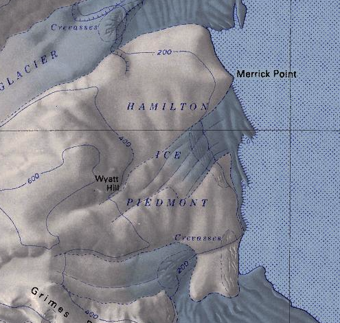
[[File:Hamilton Ice.png|350px|thumb|Hamilton Ice Piedmont map]] | |||
The '''Hamilton Ice Piedmont''' (74°30′S 110°18′W) is an [[ice]] piedmont, 8 nautical miles (15 km; 9.2 mi) wide, to the east of Wyatt Hill on the [[Bear Peninsula]]. | The '''Hamilton Ice Piedmont''' (74°30′S 110°18′W) is an [[ice]] piedmont, 8 nautical miles (15 km; 9.2 mi) wide, to the east of Wyatt Hill on the [[Bear Peninsula]]. | ||
| Line 5: | Line 6: | ||
==Discovery and name== | ==Discovery and name== | ||
The ice piedmont was mapped by the USGS using surveys and United States Navy aerial photographs collected during the years 1959-66. The Hamilton Ice Piedmont was named in 1977 by US-ACAN after Robert Hamilton, a meteorologist from the University of California, Davis who served as the USARP Station Scientific Leader at [[South Pole]] Station during the winter of 1975. | The ice piedmont was mapped by the USGS using surveys and United States Navy aerial photographs collected during the years 1959-66. The Hamilton Ice Piedmont was named in 1977 by US-ACAN after Robert Hamilton, a meteorologist from the University of California, Davis who served as the USARP Station Scientific Leader at [[South Pole]] Station during the winter of 1975. | ||
==Features== | |||
* [[Merrick Point]] | |||
* Wyatt Hill | |||
[[Category:Geography of Westarctica]] | [[Category:Geography of Westarctica]] | ||
Latest revision as of 03:12, 6 May 2024
The Hamilton Ice Piedmont (74°30′S 110°18′W) is an ice piedmont, 8 nautical miles (15 km; 9.2 mi) wide, to the east of Wyatt Hill on the Bear Peninsula.
A "piedmont" is a geographic term for any lake or glacier at the base of a mountain. This feature is notable for being one of only two piedmonts in Westarctica.
Discovery and name
The ice piedmont was mapped by the USGS using surveys and United States Navy aerial photographs collected during the years 1959-66. The Hamilton Ice Piedmont was named in 1977 by US-ACAN after Robert Hamilton, a meteorologist from the University of California, Davis who served as the USARP Station Scientific Leader at South Pole Station during the winter of 1975.
Features
- Merrick Point
- Wyatt Hill
