Difference between revisions of "Queen Elizabeth Land"
Jump to navigation
Jump to search
(page made) |
(image) |
||
| Line 1: | Line 1: | ||
[[File:BAT.png|thumb]] | |||
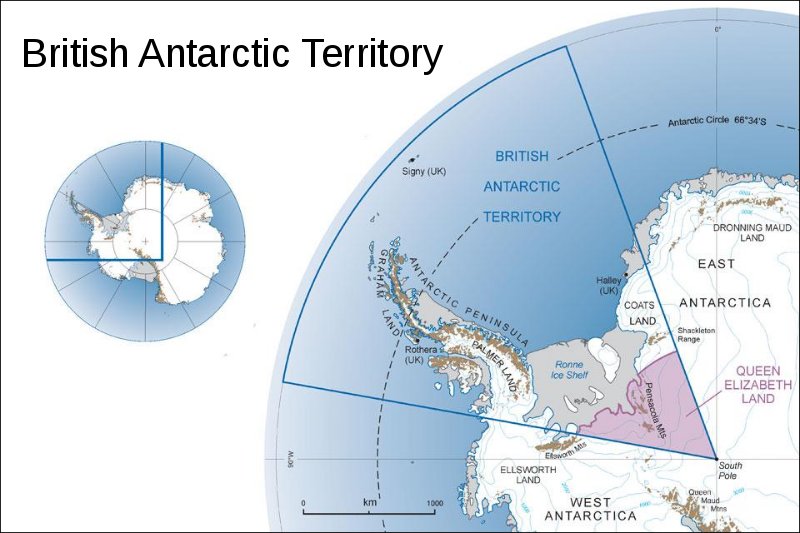
'''Queen Elizabeth Land''' is portion of mainland [[Antarctica]] named by the government of the United Kingdom and claimed as part of the [[British Antarctic Territory]], which is the largest of the 14 British Overseas Territories. Situated south of [[Weddell Sea]] and between longitudes 20°W and 80°W, stretching from [[Filchner-Ronne Ice Shelf]] to the [[South Pole]]. That territory was unnamed until 2012, though most of it was unofficially known as Edith Ronne Land in 1947–68 and includes areas claimed by the United Kingdom, Chile and Argentina. | '''Queen Elizabeth Land''' is portion of mainland [[Antarctica]] named by the government of the United Kingdom and claimed as part of the [[British Antarctic Territory]], which is the largest of the 14 British Overseas Territories. Situated south of [[Weddell Sea]] and between longitudes 20°W and 80°W, stretching from [[Filchner-Ronne Ice Shelf]] to the [[South Pole]]. That territory was unnamed until 2012, though most of it was unofficially known as Edith Ronne Land in 1947–68 and includes areas claimed by the United Kingdom, Chile and Argentina. | ||
-Credit: Wikipedia | -Credit: Wikipedia | ||
Revision as of 10:57, 7 April 2018
Queen Elizabeth Land is portion of mainland Antarctica named by the government of the United Kingdom and claimed as part of the British Antarctic Territory, which is the largest of the 14 British Overseas Territories. Situated south of Weddell Sea and between longitudes 20°W and 80°W, stretching from Filchner-Ronne Ice Shelf to the South Pole. That territory was unnamed until 2012, though most of it was unofficially known as Edith Ronne Land in 1947–68 and includes areas claimed by the United Kingdom, Chile and Argentina.
-Credit: Wikipedia
