Difference between revisions of "Konter Cliffs"
Westarctica (talk | contribs) (Created page with "thumb|350px|Map showing the Konter Cliffs The '''Konter Cliffs''' (75°6′S 137°48′W) are a line of cliffs, 360 meters (1,180 ft) high, which...") |
Westarctica (talk | contribs) |
||
| (One intermediate revision by the same user not shown) | |||
| Line 1: | Line 1: | ||
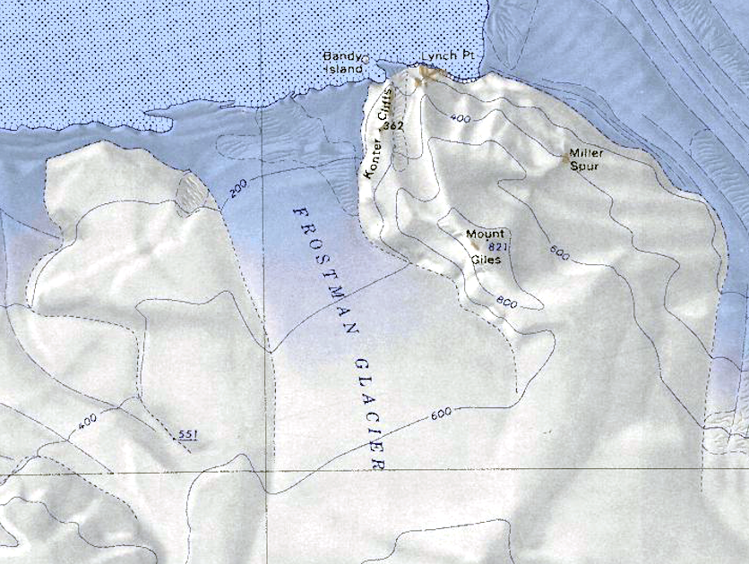
[[File:Frostman Glacier.png|thumb|350px|Map showing the Konter Cliffs]] | [[File:Frostman Glacier.png|thumb|350px|Map showing the Konter Cliffs]] | ||
The '''Konter Cliffs''' (75°6′S 137°48′W) are a line of cliffs, 360 meters (1,180 ft) high, which surmount the east side of the terminus of the [[Frostman Glacier]], on the coast of [[Westarctica]] near [[Hull Bay]]. | The '''Konter Cliffs''' (75°6′S 137°48′W) are a line of cliffs, 360 meters (1,180 ft) high, which surmount the east side of the terminus of the [[Frostman Glacier]], on the coast of [[Westarctica]] near [[Hull Bay]]. The cliffs around bounded by [[Lynch Point]] and overshadow the offshore [[Bandy Island]]. | ||
==Discovery and name== | ==Discovery and name== | ||
They were mapped by the United States Geological Survey from surveys and [[U.S. Navy]] tricamera aerial photographs, 1959–65. The Konter Cliffs were named by the Advisory Committee on [[Antarctic]] Names for Richard W. Konter, a member of the ship's party on board the ''City of New York'' during the [[Byrd Antarctic Expedition]] from 1928–30. | They were mapped by the United States Geological Survey from surveys and [[U.S. Navy]] tricamera aerial photographs, 1959–65. The Konter Cliffs were named by the Advisory Committee on [[Antarctic]] Names for Richard W. Konter, a member of the ship's party on board the ''City of New York'' during the [[Byrd Antarctic Expedition]] from 1928–30. | ||
==Peerage title== | |||
On 31 December 2024, Liam Christian Ferreira was granted the [[Peerage of Westarctica|peerage title]] Count of Konter in recognition of his support of Westarctica. His Lordship's title is named for the Konter Cliffs. | |||
[[Category: Geography of Westarctica]] | [[Category: Geography of Westarctica]] | ||
Latest revision as of 05:44, 2 January 2025
The Konter Cliffs (75°6′S 137°48′W) are a line of cliffs, 360 meters (1,180 ft) high, which surmount the east side of the terminus of the Frostman Glacier, on the coast of Westarctica near Hull Bay. The cliffs around bounded by Lynch Point and overshadow the offshore Bandy Island.
Discovery and name
They were mapped by the United States Geological Survey from surveys and U.S. Navy tricamera aerial photographs, 1959–65. The Konter Cliffs were named by the Advisory Committee on Antarctic Names for Richard W. Konter, a member of the ship's party on board the City of New York during the Byrd Antarctic Expedition from 1928–30.
Peerage title
On 31 December 2024, Liam Christian Ferreira was granted the peerage title Count of Konter in recognition of his support of Westarctica. His Lordship's title is named for the Konter Cliffs.
