Difference between revisions of "Heathcock Peak"
Jump to navigation
Jump to search
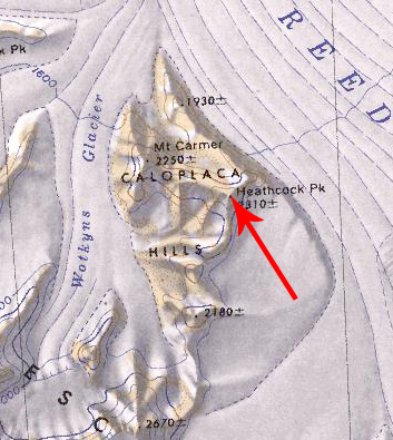
Westarctica (talk | contribs) (Created page with "350px|thumb|Map showing Heathcock Peak '''Heathcock Peak''' (86°7′S 130°40′W) is a peak, 2,310 meters (7,580 ft) high, located in the eastern...") |
Westarctica (talk | contribs) (added note on title) |
||
| Line 4: | Line 4: | ||
==Discovery and name== | ==Discovery and name== | ||
The peak was mapped by the United States Geological Survey from surveys and [[U.S. Navy]] air photos collected during the years 1960–64. Heathcock Peak was named by the Advisory Committee on Antarctic Names in honor of Joe D. Heathcock, a U.S. Navy Seabee stationed at [[Byrd Station]] in 1962. | The peak was mapped by the United States Geological Survey from surveys and [[U.S. Navy]] air photos collected during the years 1960–64. Heathcock Peak was named by the Advisory Committee on Antarctic Names in honor of Joe D. Heathcock, a U.S. Navy Seabee stationed at [[Byrd Station]] in 1962. | ||
==Peerage title== | |||
On 13 August 2024, Paul Rother was granted the [[Peerage of Westarctica|peerage title]] Count of Heathcock in recognition of his support of [[Westarctica]]. His Lordship's title is named for this peak. | |||
[[Category:Mountains]] | [[Category:Mountains]] | ||
Revision as of 13:47, 14 August 2024
Heathcock Peak (86°7′S 130°40′W) is a peak, 2,310 meters (7,580 ft) high, located in the eastern part of the Caloplaca Hills in Antarctica and overlooking the western edge of Reedy Glacier.
Discovery and name
The peak was mapped by the United States Geological Survey from surveys and U.S. Navy air photos collected during the years 1960–64. Heathcock Peak was named by the Advisory Committee on Antarctic Names in honor of Joe D. Heathcock, a U.S. Navy Seabee stationed at Byrd Station in 1962.
Peerage title
On 13 August 2024, Paul Rother was granted the peerage title Count of Heathcock in recognition of his support of Westarctica. His Lordship's title is named for this peak.
