Difference between revisions of "Buennagel Peak"
Jump to navigation
Jump to search
Westarctica (talk | contribs) (added map) |
Westarctica (talk | contribs) (added peerage note) |
||
| Line 4: | Line 4: | ||
==Discovery and name== | ==Discovery and name== | ||
It was mapped by the United States Antarctic Service (1939–41) and by the United States Geological Survey from surveys and [[U.S. Navy]] air photos (1959–65), and named by the Advisory Committee on [[Antarctic]] Names for Lawrence A. Buennagel, a geomagnetist/seismologist who served at [[Byrd Station]] during the 1968 research season. | It was mapped by the United States Antarctic Service (1939–41) and by the United States Geological Survey from surveys and [[U.S. Navy]] air photos (1959–65), and named by the Advisory Committee on [[Antarctic]] Names for Lawrence A. Buennagel, a geomagnetist/seismologist who served at [[Byrd Station]] during the 1968 research season. | ||
==Peerage title== | |||
On 21 August 2023, Lea Paulinic was granted the [[Peerage of Westarctica|peerage title]] Baroness of Buennagel. Her title was named for this peak. | |||
[[Category:Mountains]] | [[Category:Mountains]] | ||
Latest revision as of 03:55, 22 August 2023
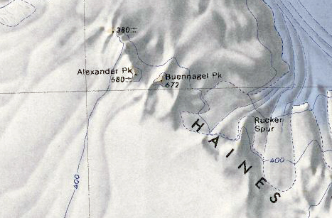
Buennagel Peak (77°30′S 146°46′W) is a rock peak 1 nautical mile (2 km) east of Alexander Peak in the north part of the Haines Mountains, in the Ford Ranges of Westarctica.
Discovery and name
It was mapped by the United States Antarctic Service (1939–41) and by the United States Geological Survey from surveys and U.S. Navy air photos (1959–65), and named by the Advisory Committee on Antarctic Names for Lawrence A. Buennagel, a geomagnetist/seismologist who served at Byrd Station during the 1968 research season.
Peerage title
On 21 August 2023, Lea Paulinic was granted the peerage title Baroness of Buennagel. Her title was named for this peak.
