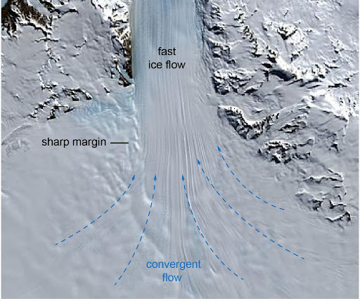
Ice Stream
An ice stream is a region of fast-moving ice within an ice sheet. It is a type of glacier, a body of ice that moves under its own weight. They can move upwards of 1,000 meters (3,300 ft) a year, and can be up to 50 kilometers (31 mi) in width, and hundreds of kilometers in length.
In Antarctica, the ice streams account for approximately 90% of the sheet's mass loss per year.
The shear forces cause deformation and recrystallization that drive the movement, this movement then causes topographic lows and valleys to form after all of the material in the ice sheet has been discharged.[3] Sediment also plays an important role in flow velocity, the softer and more easily deformed the sediment present, the easier it is for flow velocity to be higher. Most ice streams contain a layer of water at the bottom, which lubricates flow and acts to increase speed.
Antarctic ice streams
The Antarctic Ice Sheet is drained to the sea by several ice streams. The largest in East Antarctica is Lambert Glacier. In West Antarctica, the large Pine Island and Thwaites Glaciers are currently the most out of balance, with a total net mass loss of 85 gigatonnes (84 billion long tons; 94 billion short tons) per year measured in 2006.
Antarctica has many ice streams that carry billions of tons of ice to the sea a year. The Pine Island and Thwaites streams have the highest amount of net discharge in Westarctica while the Lambert Glacier leads the way in East Antarctica. The rate at which the Antarctic ice sheet is losing mass is accelerating and the past and ongoing acceleration of ice streams and outlet glaciers is considered to be a significant, if not the dominant cause of this recent imbalance. Ice streams hold serious implications for sea level rise as 90% of Antarctica's ice mass is lost through them.
While East Antarctica is generally stable, ice loss from the West Antarctic Ice Sheet has increased by 59% in the past 10 years and by 140% in the Antarctic Peninsula. Ice streams control much of the ice sheet mass budget as they dictate the amount of discharge that comes off an ice sheet. Geomorphic features such as bathymetric troughs indicate where paleo-ice streams in Antarctica extended during the Last Glacial Maximum (LGM). Analysis of landforms diagnostic of paleo-ice streams, revealed considerable asynchronicity in individual ice stream retreat histories. This notion is important when considering how the underlying geomorphology of ice streams control at what rate and how they retreat. Furthermore, this reinforces the importance of internal factors such as bed characteristic, slope, and drainage basin size in determining ice stream dynamics.
Geomorphology
As ice streams drain into the surrounding ocean, not only does this increase the sea level due to displacement of the ice runoff, but also by increasing the volumetric content of the oceans themselves, but this is almost negligible. As ice streams diminish in size, the pressure they exert on surrounding features like glaciers reduces, allowing the glacier that feeds into the sea to speed up and discharge more quickly, rising sea level.
This rise in sea level affects both topography and bathymetry in the regions directly affected by the ice stream in question. As a result of this rise in sea level, albeit slow and almost minute in short scales but large over longer scales, the landscape will be altered. Rising sea levels will weather the surrounding sheet and cause erosion and deformation of the sheet itself, thus altering the landscape and morphology.
