Difference between revisions of "Kuberry Rocks"
Jump to navigation
Jump to search
Westarctica (talk | contribs) (Created page with "thumb|350px|Map of the Coulter Heights showing location of Kuberry Rocks The '''Kuberry Rocks''' (75°17′S 138°31′W) are a small area of expo...") |
Westarctica (talk | contribs) |
||
| (One intermediate revision by the same user not shown) | |||
| Line 1: | Line 1: | ||
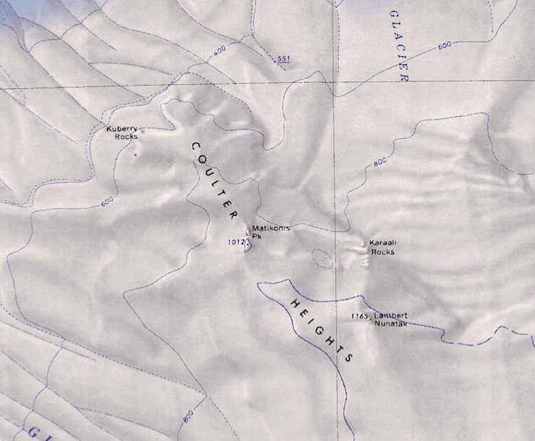
[[File:Coulter Heights.png|thumb|350px|Map of the Coulter Heights showing location of Kuberry Rocks]] | [[File:Coulter Heights.png|thumb|350px|Map of the Coulter Heights showing location of Kuberry Rocks]] | ||
The '''Kuberry Rocks''' (75°17′S 138°31′W) are a small area of exposed rock at the north end of the [[Coulter Heights]]. The rocks are 6 nautical miles (11 km) northwest of Matikonis Peak, near the | The '''Kuberry Rocks''' (75°17′S 138°31′W) are a small area of exposed rock at the north end of the [[Coulter Heights]]. The rocks are 6 nautical miles (11 km) northwest of [[Matikonis Peak]], near [[Shuman Glacier]] on the [[Ruppert Coast]] of [[Westarctica]]. | ||
==Discovery and name== | ==Discovery and name== | ||
Latest revision as of 20:17, 22 August 2023
The Kuberry Rocks (75°17′S 138°31′W) are a small area of exposed rock at the north end of the Coulter Heights. The rocks are 6 nautical miles (11 km) northwest of Matikonis Peak, near Shuman Glacier on the Ruppert Coast of Westarctica.
Discovery and name
They were mapped by the United States Geological Survey from surveys and U.S. Navy air photos taken during 1959–65. The Kuberry Rocks were named by the Advisory Committee on Antarctic Names for Richard W. Kuberry, a geomagnetist/seismologist at Byrd Station during the 1969–70 season.
Peerage title
On 17 January 2019, Alina-Maria Leitner was granted the peerage title Baroness Kuberry.
