Difference between revisions of "Crosson Ice Shelf"
Jump to navigation
Jump to search
Westarctica (talk | contribs) (Created page with "thumb|Crosson Ice Shelf (center left) and Mount Murphy (foreground) '''Crosson Ice Shelf''' (74°57′S 109°30′W) is an Antarctica|Antarct...") |
(map) |
||
| Line 1: | Line 1: | ||
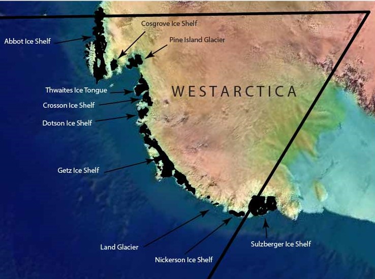
[[File: | [[File:ice features.jpg|right|600px]] | ||
'''Crosson Ice Shelf''' (74°57′S 109°30′W) is an [[Antarctica|Antarctic]] [[ice-shelf|ice shelf]], about 35 miles (56 km) wide, north and northeast of [[Mount Murphy]] along the [[Walgreen Coast]] of [[Westarctica]]. | '''Crosson Ice Shelf''' (74°57′S 109°30′W) is an [[Antarctica|Antarctic]] [[ice-shelf|ice shelf]], about 35 miles (56 km) wide, north and northeast of [[Mount Murphy]] along the [[Walgreen Coast]] of [[Westarctica]]. | ||
Revision as of 04:45, 1 May 2018

Crosson Ice Shelf (74°57′S 109°30′W) is an Antarctic ice shelf, about 35 miles (56 km) wide, north and northeast of Mount Murphy along the Walgreen Coast of Westarctica.
The ice shelf is nurtured by the Smith, Pope, Vane, and Haynes Glaciers.
Discovery and name
It was mapped by the U.S. Geological Survey from surveys and from U.S. Navy air photos, 1959–66.
Crosson Ice Shelf was named by the Advisory Committee on Antarctic Names for Commander W.E. Crosson, U.S. Navy, Commanding Officer of the Antarctic Construction Group during Operation Deep Freeze 1973.