Difference between revisions of "Canisteo Peninsula"
Jump to navigation
Jump to search
Westarctica (talk | contribs) |
(added note on WPS consideration) |
||
| (One intermediate revision by one other user not shown) | |||
| Line 1: | Line 1: | ||
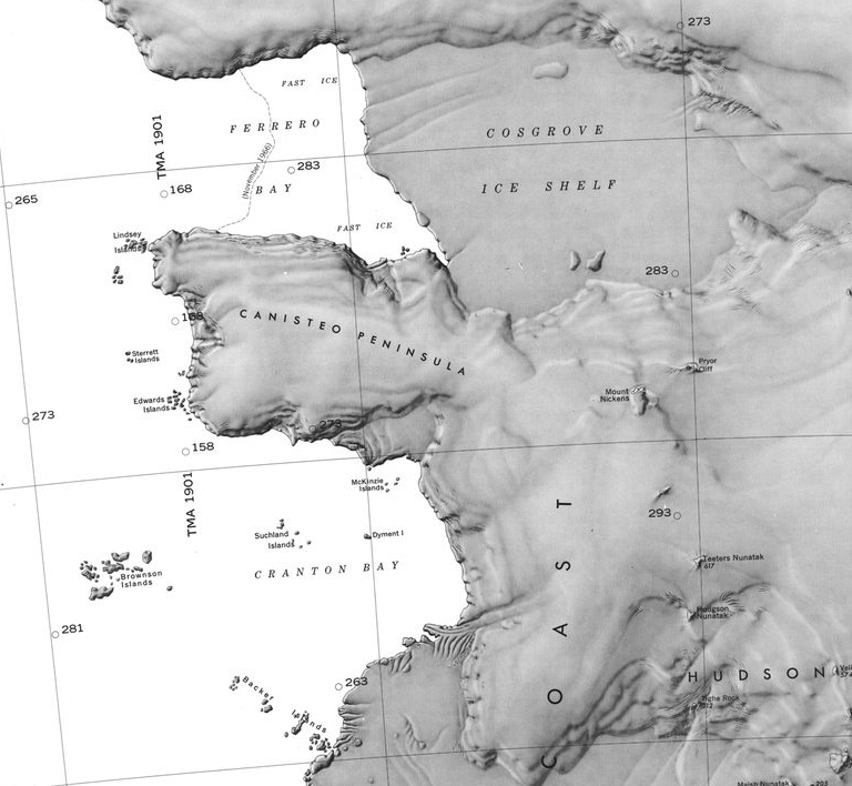
[[File:Canisteo County1.jpg|thumb|Shaded relief map showing the Canisteo Peninsula]] | [[File:Canisteo County1.jpg|thumb|Shaded relief map showing the Canisteo Peninsula]] | ||
The '''Canisteo Peninsula''' ( | The '''Canisteo Peninsula''' (73°48′S 102°20′W) is an [[ice]]-covered peninsula, about 30 miles (50 km) long and 20 miles (30 km) wide, which projects between Ferrero Bay and [[Cranton Bay]] into the eastern extremity of the [[Amundsen Sea]]. | ||
==Discovery and name== | ==Discovery and name== | ||
It was delineated from air photos taken by U.S. Navy Operation Highjump in December 1946, and named by the Advisory Committee on [[Antarctica|Antarctic]] Names for the USS ''Canisteo'', a tanker with the eastern task group of this expedition. | It was delineated from air photos taken by [[U.S. Navy]] Operation Highjump in December 1946, and named by the Advisory Committee on [[Antarctica|Antarctic]] Names for the USS ''Canisteo'', a tanker with the eastern task group of this expedition. | ||
===Count of Canisteo=== | ===Count of Canisteo=== | ||
In 2014, professional singer and vocal coach to [[Grand Duke Travis]], Griffith Frank, was granted the title [[Count of Canisteo]] in recognition of his services to the Crown. | In 2014, professional singer and vocal coach to [[Grand Duke Travis]], Griffith Frank, was granted the title [[Count of Canisteo]] in recognition of his services to the Crown. | ||
==Protection by the government== | |||
The area had been identified as a candidate for protection under the [[Westarctican Parks Service]]. | |||
[[Category:Geography of Westarctica]] | [[Category:Geography of Westarctica]] | ||
Latest revision as of 21:05, 28 April 2025
The Canisteo Peninsula (73°48′S 102°20′W) is an ice-covered peninsula, about 30 miles (50 km) long and 20 miles (30 km) wide, which projects between Ferrero Bay and Cranton Bay into the eastern extremity of the Amundsen Sea.
Discovery and name
It was delineated from air photos taken by U.S. Navy Operation Highjump in December 1946, and named by the Advisory Committee on Antarctic Names for the USS Canisteo, a tanker with the eastern task group of this expedition.
Count of Canisteo
In 2014, professional singer and vocal coach to Grand Duke Travis, Griffith Frank, was granted the title Count of Canisteo in recognition of his services to the Crown.
Protection by the government
The area had been identified as a candidate for protection under the Westarctican Parks Service.
