Difference between revisions of "Wright Island"
Jump to navigation
Jump to search
Westarctica (talk | contribs) (Source of article predominately from Wikipedia article on Wright Island) |
Westarctica (talk | contribs) m |
||
| Line 8: | Line 8: | ||
[[Category:Islands]] | [[Category:Islands]] | ||
[Category:Geography of Westarctica]] | [[Category:Geography of Westarctica]] | ||
Revision as of 19:21, 30 April 2018
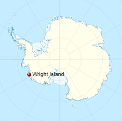
Wright Island is an ice-covered island 65 km (35 nmi) long, lying at the north edge of Getz Ice Shelf about midway between Carney Island and the Martin Peninsula, on the Bakutis Coast of Westarctica.
Discovery and name
The island was delineated from air photos taken by U.S. Navy Operation Highjump in January 1947.
Wright Island was damed by Advisory Committee on Antarctic Names after Admiral Jerauld Wright, U.S. Navy, Commander in Chief, Atlantic Fleet, in over-all command of the U.S. Navy's Deep Freeze operations during the IGY, 1957-58.
