Search results
Jump to navigation
Jump to search
Page title matches
- 64 members (2 subcategories, 0 files) - 07:28, 26 March 2018
- [[File:LINDSEY.jpg|thumb|right|The Edwards Islands]] The '''Edwards Islands''' (75.53S, 103.08W) are about 20 small islands, mostly ice free in summer, lying off the south-western tip of the [[Canist1 KB (157 words) - 20:13, 17 March 2021
- ...:McKinzie Islands.jpg|350px|thumb|Map showing the location of the McKinzie Islands in Antarctica]] The '''McKinzie Islands''' are a group of small islands in the northeastern extremity of [[Cranton Bay]].1 KB (166 words) - 13:11, 15 July 2020
- [[File:Suchland Islands.jpg|350px|thumb|Scientist at the Suchland Islands taking a GPS reading]] The '''Suchland Islands''' (74°6′S 102°32′W) are a group of 8 small islands lying just inside the central part of the mouth of [[Cranton Bay]].869 bytes (129 words) - 07:27, 2 November 2021
- ...Cape Waite.jpg|350px|thumb|Glaciological map showing location of the Waite Islands]] ...the [[King Peninsula]] of [[Westarctica]]. They consist of a total of five islands, and are composed of diorite-granodiorite rock.687 bytes (101 words) - 06:21, 7 October 2019
- ...x|thumb|Map of Cranton Bay and the Canisteo Peninsula showing the Brownson Islands]] The '''Brownson Islands ''' (74°10′S 103°36′W) are a group of about 20 small islands which lie just outside the entrance to [[Cranton Bay]], about 14 nautical m2 KB (321 words) - 22:49, 26 June 2020
- ...isteo Peninsula]] and 2 nautical miles (3.7 km) southwest of the [[Lindsey Islands]]. The Schaefer Islands were mapped from air photos taken by [[U.S. Navy]] Operation Highjump in De709 bytes (104 words) - 03:33, 9 July 2018
- ...ds.png|350px|thumb|Satellite view showing the western group of the Lindsey Islands. Not pictured is the largest island just slightly to the east.]] The '''Lindsey Islands''' (73°37′S 103°18′W) are a group of islands lying just off the northwest tip of the [[Canisteo Peninsula]] in the [[Amu4 KB (598 words) - 02:37, 3 March 2021
- [[File:Backer Islands GPS.jpg|350px|thumb|GPS monitoring site at the Backer Islands]] ...''' are a chain of small islands at the south side of [[Cranton Bay]]. The islands trend northwest for 22 kilometers (12 nmi) from the [[ice shelf]] which for948 bytes (147 words) - 04:16, 2 January 2019
- #redirect[[Balleny Islands]]28 bytes (3 words) - 12:01, 7 April 2018
- 8 members (0 subcategories, 0 files) - 02:36, 17 March 2024
- |+ style="font-size: 160%; margin-left: inherit;" |'''The Balleny Islands''' ...c origin. [[glacier|Glaciers]] project from their slopes into the sea. The islands were formed by the so-called Balleny hotspot. They were originally claimed10 KB (1,478 words) - 02:39, 16 March 2024
- ...,687 square kilometers (1,424 sq mi). By the Antarctic Treaty of 1959, the islands' sovereignty is neither recognized nor disputed by the signatories and they The islands have been claimed by the United Kingdom since 1908 and have been part of th955 bytes (140 words) - 16:58, 16 May 2018
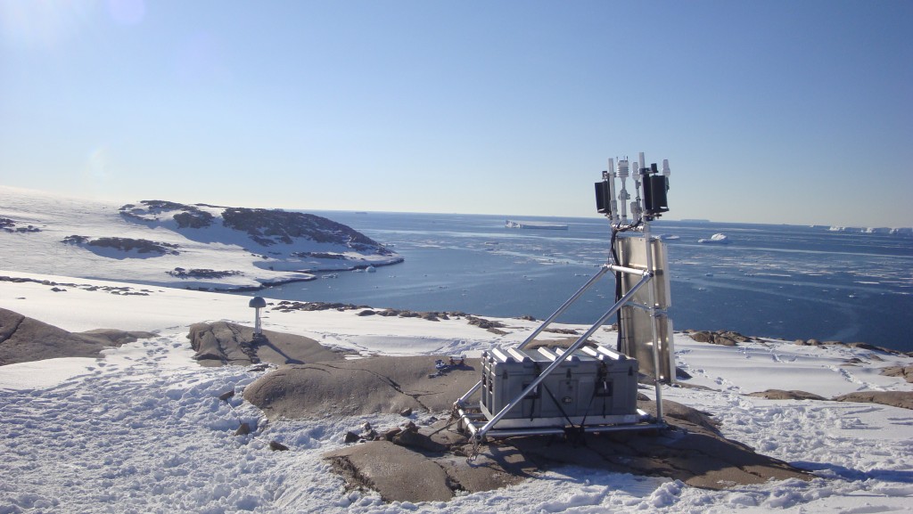
File:Backer Islands GPS.jpg GPS monitoring station located on the Backer Islands. View is looking toward Cranston Bay.(1,024 × 577 (137 KB)) - 05:51, 1 April 2019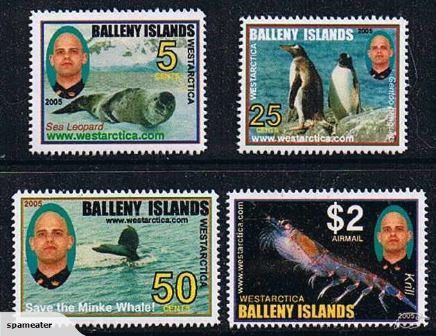
File:Balleny Islands - Krill.jpg Semi-unauthorized stamps of the Balleny Islands.(629 × 484 (103 KB)) - 06:29, 27 March 2018
File:Coin-Islands SET 2008.jpg (592 × 307 (58 KB)) - 19:18, 21 March 2018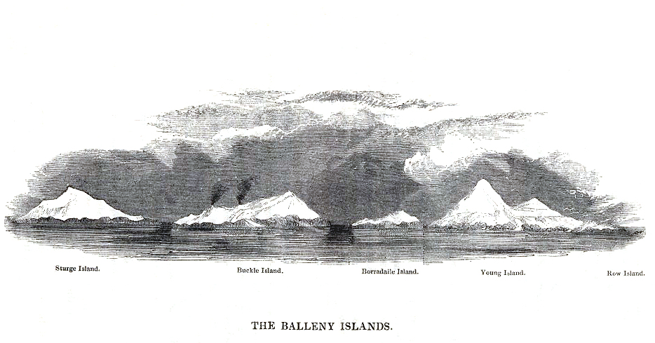
File:Balleny Islands - 1839 Enderby copy.jpg 1839 etching of the Balleny Islands by C. Enderby.(934 × 489 (308 KB)) - 22:05, 8 April 2018


Page text matches
- ...isteo Peninsula]] and 2 nautical miles (3.7 km) southwest of the [[Lindsey Islands]]. The Schaefer Islands were mapped from air photos taken by [[U.S. Navy]] Operation Highjump in De709 bytes (104 words) - 03:33, 9 July 2018
- ...Cape Waite.jpg|350px|thumb|Glaciological map showing location of the Waite Islands]] ...the [[King Peninsula]] of [[Westarctica]]. They consist of a total of five islands, and are composed of diorite-granodiorite rock.687 bytes (101 words) - 06:21, 7 October 2019
File:Young Island-Balleny Islands.jpg Description Balleny Islands: Young Island Location Balleny Islands(808 × 648 (115 KB)) - 06:41, 26 March 2018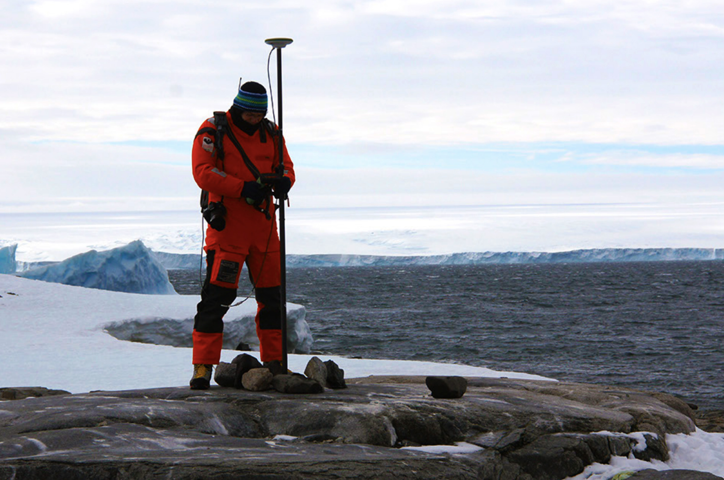
File:Suchland Islands.jpg Scientist at the Suchland Islands taking a GPS reading. Location: Suchland Islands, Antarctica(2,434 × 1,614 (649 KB)) - 22:26, 26 June 2020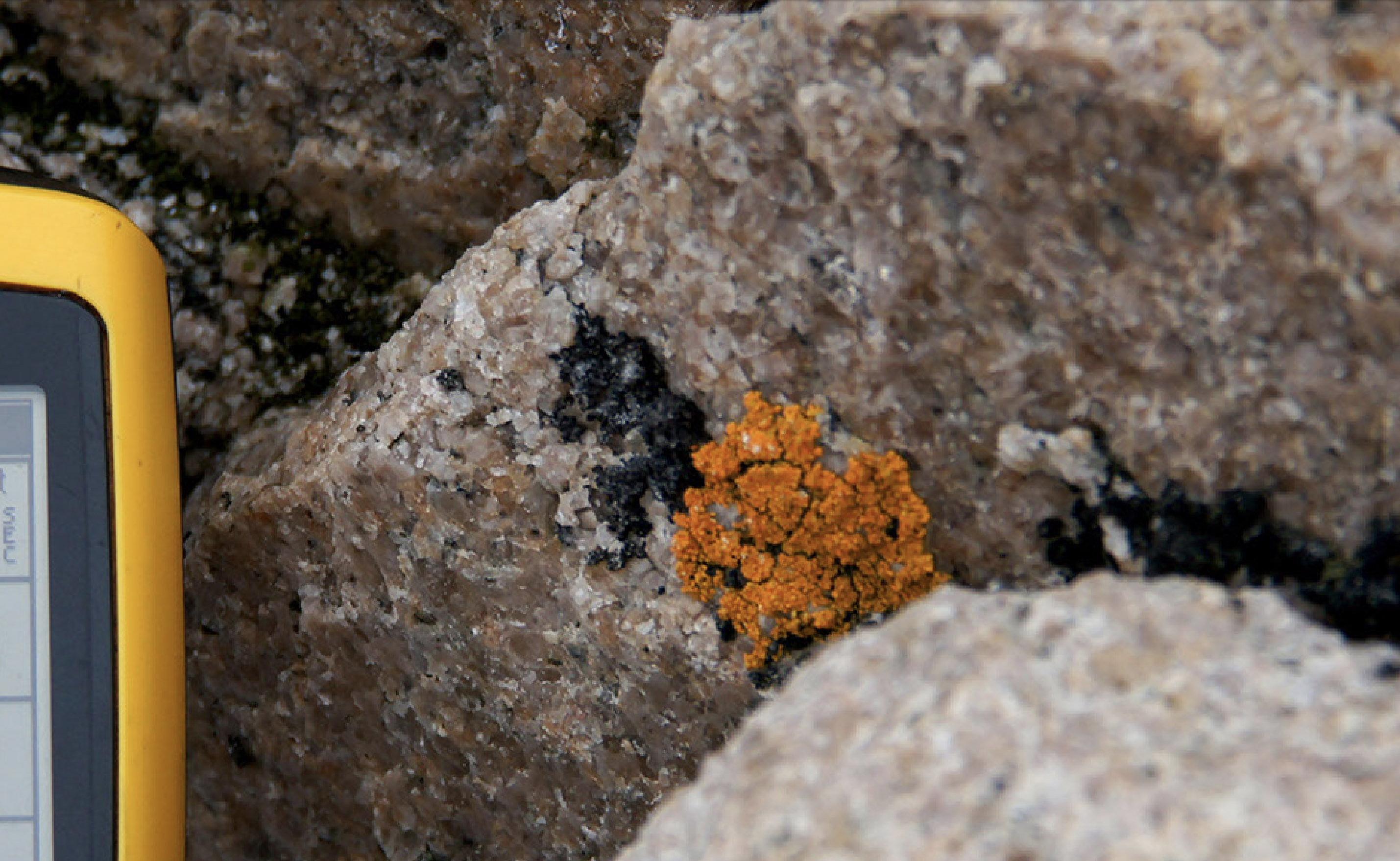
File:Brownson Island Lichens.jpg Description: Black and yellow lichens on a granite boulder in the Brownson Islands. Location: Brownson Islands, Antarctica(2,858 × 1,758 (819 KB)) - 22:49, 26 June 2020- [[File:Backer Islands GPS.jpg|350px|thumb|GPS monitoring site at the Backer Islands]] ...''' are a chain of small islands at the south side of [[Cranton Bay]]. The islands trend northwest for 22 kilometers (12 nmi) from the [[ice shelf]] which for948 bytes (147 words) - 04:16, 2 January 2019
- [[File:Suchland Islands.jpg|350px|thumb|Scientist at the Suchland Islands taking a GPS reading]] The '''Suchland Islands''' (74°6′S 102°32′W) are a group of 8 small islands lying just inside the central part of the mouth of [[Cranton Bay]].869 bytes (129 words) - 07:27, 2 November 2021
- ...:McKinzie Islands.jpg|350px|thumb|Map showing the location of the McKinzie Islands in Antarctica]] The '''McKinzie Islands''' are a group of small islands in the northeastern extremity of [[Cranton Bay]].1 KB (166 words) - 13:11, 15 July 2020
- '''The Monolith''' is a group of two small islands in the [[Balleny Islands]] to the immediate south of [[Sabrina Island]]. It rises 360 ft high and is ...ap penguin]]s, which have established breeding colonies on the neighboring islands. The Monolith stands as a bleak dagger of barren rock pointing directly upw805 bytes (123 words) - 19:03, 17 September 2018
File:Chinstrap Island Picture.png Oblique aerial picture of Chinstrap Island, in the Balleny Islands. Location: Chinstrap Island, Balleny Islands(782 × 490 (501 KB)) - 21:58, 13 January 2019- [[File:LINDSEY.jpg|thumb|right|The Edwards Islands]] The '''Edwards Islands''' (75.53S, 103.08W) are about 20 small islands, mostly ice free in summer, lying off the south-western tip of the [[Canist1 KB (157 words) - 20:13, 17 March 2021
- ...,687 square kilometers (1,424 sq mi). By the Antarctic Treaty of 1959, the islands' sovereignty is neither recognized nor disputed by the signatories and they The islands have been claimed by the United Kingdom since 1908 and have been part of th955 bytes (140 words) - 16:58, 16 May 2018
- ...n [[Westarctica]]. The southern limit of the bay is formed by the [[Backer Islands]] and an [[ice shelf]] which separates this bay from [[Pine Island Bay]]. ...His original title, Baron of Brownson, was named for the nearby [[Brownson Islands]].1 KB (175 words) - 20:14, 17 March 2021
- ...'''Marshall Archipelago''' is an extensive group of large [[ice]]-covered islands within the [[Sulzberger Ice Shelf]] off the coast of [[Westarctica]]'s [[Gu Several of the islands were discovered and plotted by the Byrd Antarctic Expeditions (1928–30 an2 KB (231 words) - 10:18, 2 January 2021
- #redirect[[Balleny Islands]]28 bytes (3 words) - 12:01, 7 April 2018
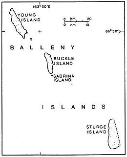
File:Balleny Map.jpg Map of the Balleny Islands.(260 × 321 (12 KB)) - 22:44, 16 March 2018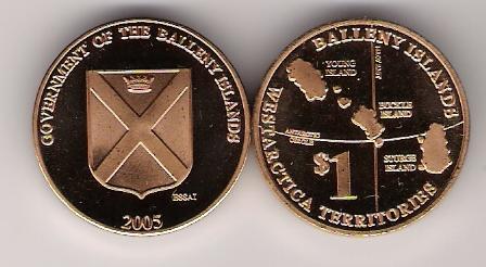
File:Coin-Balleny Island 1 2005 Bronze.jpg $1 coin of the Balleny Islands.(448 × 246 (24 KB)) - 19:25, 21 March 2018File:Balleny Islands - Krill.jpg Semi-unauthorized stamps of the Balleny Islands.(629 × 484 (103 KB)) - 06:29, 27 March 2018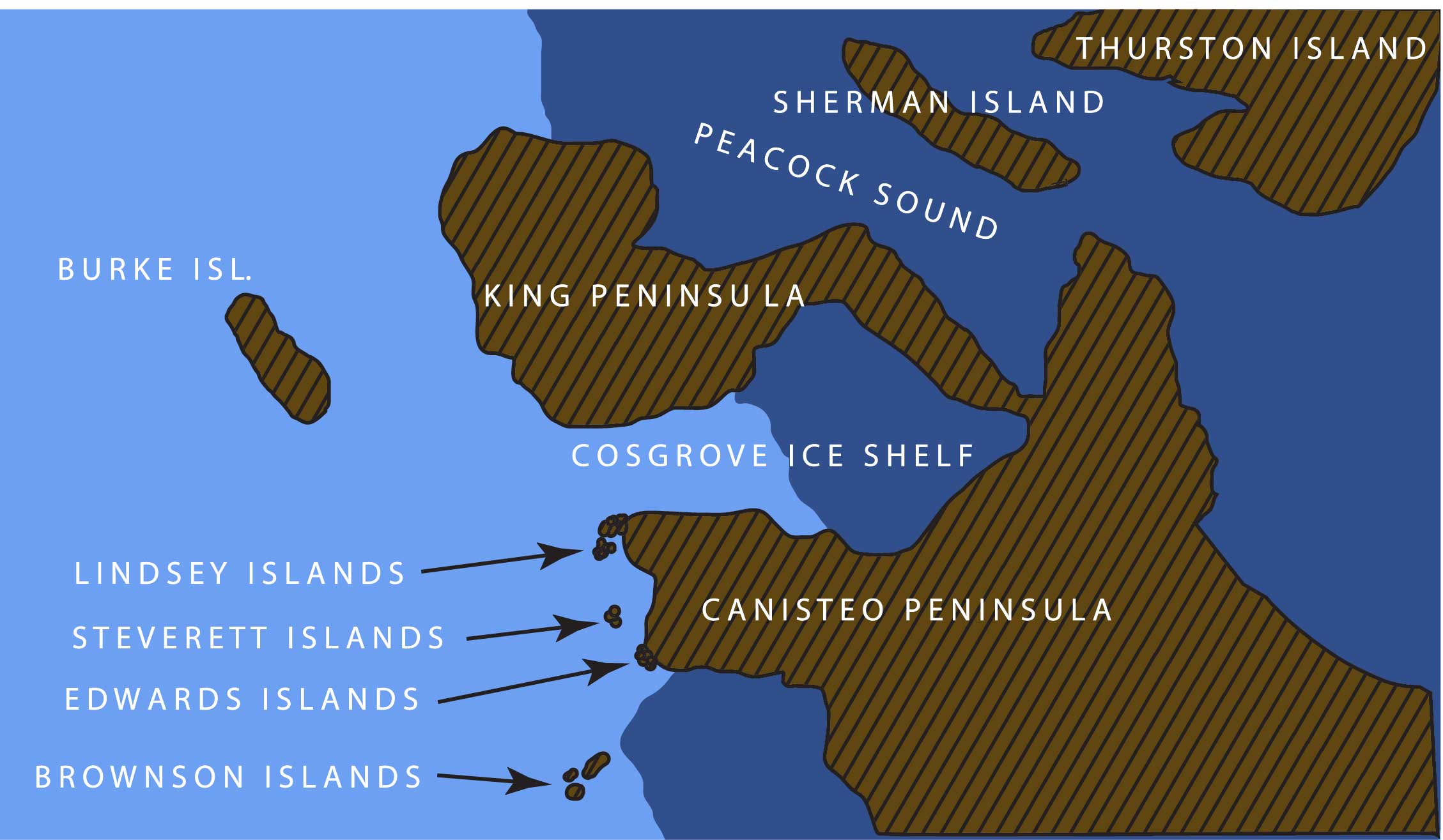
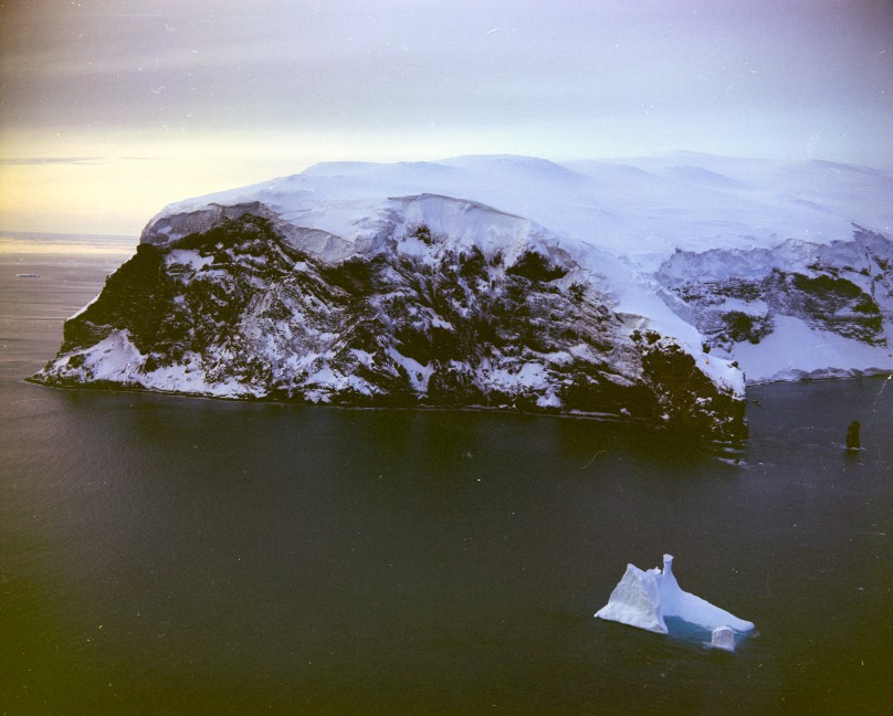
File:LINDSEY.jpg Steverett, Lindsey, Brownson, and Edwards Islands, Westarctica(2,258 × 1,315 (227 KB)) - 09:21, 9 July 2018File:Balleny Islands - 1839 Enderby copy.jpg 1839 etching of the Balleny Islands by C. Enderby.(934 × 489 (308 KB)) - 22:05, 8 April 2018


