Search results
Jump to navigation
Jump to search
Page title matches
- ...73°14′S 124°55′W) is a small [[ice]]-covered island lying close to [[Siple Island]] in the west extremity of Russell Bay, off the coast of [[Westarctica]]. ...l Survey from ground surveys and [[U.S. Navy]] air photos, 1959-65. Pranke Island was named for James B. Pranke, an aurora researcher at [[Byrd Station]] in927 bytes (138 words) - 04:52, 10 May 2018
- ...|400px|thumb|Composite map showing the 150 degree line dividing Cronenwett Island between New Zealand (Ross Dependency) and Westarctica]] ...rs (20 nmi) long. It lies between [[Przybyszewski Island]] and [[Steventon Island]] in the [[Marshall Archipelago]], off the coast of [[Westarctica]].1 KB (153 words) - 08:39, 11 March 2022
- ...eters (9 nmi) long, lying within [[Getz Ice Shelf]] just south of [[Wright Island]], along the coast of [[Westarctica]].584 bytes (85 words) - 15:54, 11 May 2018
- [[File:Forrester-Island.png|400px|thumb|Map of Forrester Island]] ...st]] of [[Westarctica]]. Its ice cap is approximately 100m thick, and the island's total height including ice cap is recorded at 171m.1,009 bytes (145 words) - 18:11, 7 September 2021
- [[File:Driscoll-Island.png|350px|thumb|Map of Driscoll Island]] '''Driscoll Island''' is a narrow, [[ice]]-covered island 30 kilometers (16 nmi) long, lying in [[Block Bay]] along the coast of [[We2 KB (220 words) - 18:27, 31 October 2019
- ...ed rock, lying 13 kilometers (7 nmi) north of the northwest end of [[Siple Island]], off the coast of [[Westarctica]]. The island is one of three considered closest to the Oceanic Pole of Inaccessibility,694 bytes (101 words) - 16:55, 14 May 2018
- [[File:Cruzen-Island.png|350px|thumb|Map of Cruzen Island]] '''Cruzen Island''' is a rocky, but mostly snow-covered island about 93 kilometers (50 nmi) north-northeast of the mouth of the [[Land Gla722 bytes (111 words) - 09:22, 16 January 2019
- [[File:Groves-Island.png|350px|thumb|Map showing Groves Island]] '''Groves Island''' is an [[ice]]-covered island 9 kilometers (5 nmi) long, lying close off the coast of [[Westarctica]], be898 bytes (129 words) - 05:13, 17 May 2018
- ...km) long in eastern [[Amundsen Sea]] of [[Westarctica]]. It is the largest island of a small group lying 38 nautical miles (70 km) west-southwest of the [[Ca ...s Antarctic Research Program's glaciological-geophysical work at Roosevelt Island during the 1961-62 research season and on traverses from [[Byrd Station]] d986 bytes (143 words) - 00:25, 10 January 2021
- 27 bytes (3 words) - 14:23, 28 September 2018
- 12 members (0 subcategories, 0 files) - 05:02, 11 March 2022
- ...ock Sound-Islands.png|350px|thumb|Map showing Carpenter Island and Sherman Island in the Peacock Sound]] Carpenter Island (72°41'S 97°57'W) is a 7 mile long oval-shaped island located in the [[Peacock Sound]].1 KB (205 words) - 17:02, 8 May 2024
- ...ying 19 kilometers (10 nmi) east of [[Cape Dart]] off the coast of [[Siple Island]]. ...[U.S. Navy]] aerial photography collected during the years 1962–65. Burtis Island was named by the Advisory Committee on [[Antarctic]] Names for William J. B678 bytes (98 words) - 05:14, 11 March 2022
- [[File:Marshall-Islands.png|350px|thumb|Map showing location of Grinder Island in relation to other islands in the southwest Marshall Archipelago]] ...ters (1 nmi) wide and lies 24 kilometers (13 nmi) southwest of [[Steventon Island]].827 bytes (120 words) - 16:24, 18 December 2019
- [[File:Bandy Island.jpg|350px|thumb|USGS Chart showing Bandy Island]] '''Bandy Island''' (75°4′S 137°49′W) is a small [[ice]]-covered island lying in [[Hull Bay]], 3 kilometers (1.5 nmi) west of [[Lynch Point]] in co1 KB (158 words) - 18:05, 24 January 2023
- [[File:Young Island-Balleny Islands.jpg|thumb|350px|right|Tip of Young Island]] ...he [[Southern Ocean]]. It lies 8 kilometers (5.0 mi) northwest of [[Buckle Island]], some 115 kilometers (71 mi) north-northeast of Belousov Point on the [[A2 KB (340 words) - 20:12, 8 June 2023
- 10 members (0 subcategories, 0 files) - 23:36, 4 September 2021
- ...d island 19 kilometers (10 nmi) long, between Kizer Island and [[Steventon Island]] in the [[Sulzberger Ice Shelf]]. ...nd from [[U.S. Navy]] air photos collected during the years 1959–65. Moody Island was named by the Advisory Committee on [[Antarctic]] Names for E.L. Moody,500 bytes (72 words) - 17:44, 4 September 2021
- ...Westside-Balleny Islands.jpg|thumb|350.px|right|The western side of Buckle Island]] ...mi) north-west of [[Sturge Island]] and 8 km (5 mi) south-east of [[Young Island]], some 110 km (68 mi) north-north-east of Belousov Point on the Antarctic2 KB (348 words) - 05:18, 27 March 2018
- [[File:Kramer Island.jpg|350px|thumb|Map showing Kramer island]] '''Kramer Island''' is an ice-covered island, 4 kilometers (2 nmi) long, in the [[Marshall Archipelago]].829 bytes (115 words) - 07:19, 2 November 2021
Page text matches
- ...ying 19 kilometers (10 nmi) east of [[Cape Dart]] off the coast of [[Siple Island]]. ...[U.S. Navy]] aerial photography collected during the years 1962–65. Burtis Island was named by the Advisory Committee on [[Antarctic]] Names for William J. B678 bytes (98 words) - 05:14, 11 March 2022
- [[File:Dryment Island.jpg|350px|thumb|Rock formations on Dyment Island]] '''Dyment Island''' is a small island lying 9 kilometers (5 nmi) southwest of the [[McKinzie Islands]] in the inn587 bytes (89 words) - 00:49, 4 July 2020
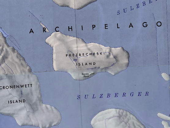
File:Prezbecheski Island.jpg ...byszewski Island. Note that the USGS chart has misspelled the name of the island.(556 × 420 (166 KB)) - 18:26, 2 December 2019- [[File:Madden Island.jpg|350px|thumb|Map showing the location of Madden Island in the Marshall Archipelago]] ...n the [[Marshall Archipelago]]. It lies between Moody Island and [[Grinder Island]] in the [[Sulzberger Ice Shelf]].900 bytes (130 words) - 02:36, 4 April 2021
File:Borradaile Island - Balleny.jpg Description: Borradaile Island, Balleny Group Location: Borradaile Island(881 × 595 (91 KB)) - 21:30, 16 March 2019- [[File:Loc-wright.jpg|thumb|200px|Location of Wright Island]] ...ing at the north edge of [[Scott Peninsula]] about midway between [[Carney Island]] and the [[Martin Peninsula]], on the [[Bakutis Coast]] of [[Westarctica]]1 KB (190 words) - 08:17, 17 January 2021
- '''Newman Island''' is an [[ice]]-covered island 28 kilometers (15 nmi) long, lying in the [[Nickerson Ice Shelf]] on the co ...y the United States Geological Survey and [[U.S. Navy]] air photos. Newman Island was named by the Advisory Committee on [[Antarctic]] Names in honor of Cdr.517 bytes (81 words) - 15:35, 16 September 2019
- [[File:Kramer Island.jpg|350px|thumb|Map showing Kramer island]] '''Kramer Island''' is an ice-covered island, 4 kilometers (2 nmi) long, in the [[Marshall Archipelago]].829 bytes (115 words) - 07:19, 2 November 2021
- [[File:Cherry-Island.jpg|350px|thumb|Map showing the location of Cherry Island]] ...e]]-covered island, 3 mi long, lying between [[Siple Island]] and [[Carney Island]] within the [[Getz Ice Shelf]], along the northern coast of [[Westarctica]961 bytes (143 words) - 06:46, 22 April 2019
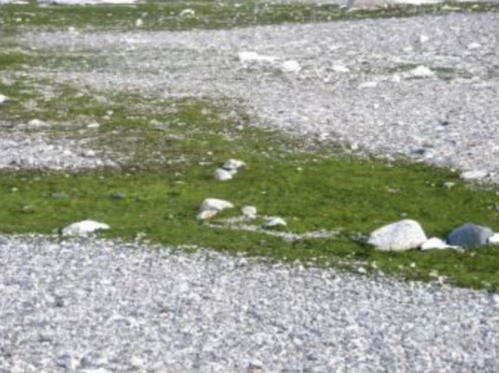
File:Lindsey Island Algae.png ...crispa'' algae in bloom on Lindsey Island. This algae is prominent on the island due to the biosoils deposited by the penguin colonies there.(717 × 537 (665 KB)) - 19:43, 7 July 2018- [[File:Forrester-Island.png|400px|thumb|Map of Forrester Island]] ...st]] of [[Westarctica]]. Its ice cap is approximately 100m thick, and the island's total height including ice cap is recorded at 171m.1,009 bytes (145 words) - 18:11, 7 September 2021
- [[File:Marshall-Islands.png|350px|thumb|Map showing location of Grinder Island in relation to other islands in the southwest Marshall Archipelago]] ...ters (1 nmi) wide and lies 24 kilometers (13 nmi) southwest of [[Steventon Island]].827 bytes (120 words) - 16:24, 18 December 2019
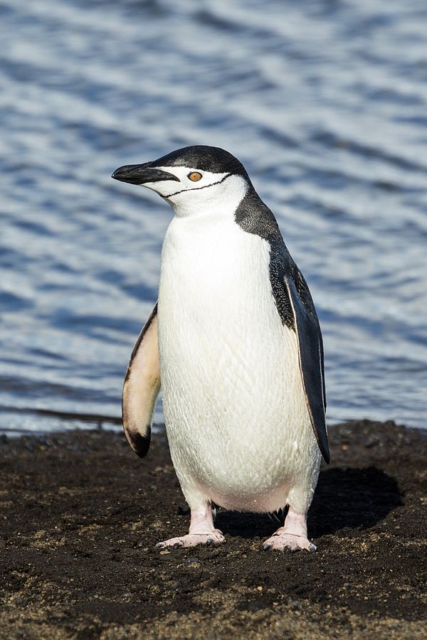
File:Chinstrap penguin-Deception.jpg Description: Chinstrap Penguin on Deception Island. Location: Deception Island, Antarctica(600 × 900 (93 KB)) - 00:25, 10 October 2021- ...ap showing the location of Lauff and Burtis Islands off the coast of Siple Island.]] ...small island lying 4 kilometers (2 nmi) north of [[Cape Dart]] and [[Siple Island]] along the [[Bakutis Coast]] of [[Westarctica]].1 KB (154 words) - 05:15, 11 March 2022
- [[File:Getz Ice Shelf to Bear Island.jpg|thumb|upright=2.0]] ...hin the [[Getz Ice Shelf]] and midway between [[Grant Island]] and [[Siple Island]], off the coast of [[Westarctica]].977 bytes (149 words) - 18:23, 24 January 2023
- [[File:Benton-Island-Map.jpg|thumb|500px|Map showing Benton Island in the Marshall Archipelago]] ...lying 9 kilometers (5 nmi) northwest of [[Nolan Island]] near [[Steventon Island]] in the [[Marshall Archipelago]].965 bytes (138 words) - 10:00, 2 January 2021
- [[File:Barony of Moore.jpg|thumb|350px|Map showing the location of Farmer Island]] ...6 miles north of [[Radford Island]] and 5 nautical miles east of [[Morris Island]] in the [[Marshall Archipelago]] along the coast of [[Westarctica]].1 KB (158 words) - 21:56, 23 November 2021
- [[File:Sabrina Island1.png|thumb|Sabrina Island from the air]] ...the largest of three small islets lying 1.5 km (0.93 mi) south of [[Buckle Island]] in the [[Balleny Islands]] off the coast of continental [[Antarctica]].2 KB (237 words) - 06:59, 23 December 2019
- ...|400px|thumb|Composite map showing the 150 degree line dividing Cronenwett Island between New Zealand (Ross Dependency) and Westarctica]] ...rs (20 nmi) long. It lies between [[Przybyszewski Island]] and [[Steventon Island]] in the [[Marshall Archipelago]], off the coast of [[Westarctica]].1 KB (153 words) - 08:39, 11 March 2022
- [[File:Roos island.jpg|thumb]]'''Roosevelt Island''' is an [[ice]]-covered island, about 130 kilometers long in a NW-SE direction, 65 kilometers wide and abo ...of how the ice flows above it establishes the existence and extent of the island.1 KB (162 words) - 08:10, 1 April 2019


